Categories
Hiking the PCT

Trip of a Lifetime

     Trip of a lifetime
     Unfolding body and mind
     into everything
          Ribs

I touched the northern terminus of the Pacific Crest Trail on Thursday, August 19th at 10:36 a.m. after hiking 2,653.6 miles in 118 days. What truly surprised me, and I will never forget, is the rousing cheer from the ten thru-hikers serendipitously gathered at the end of their journeys. A Canadian woman named Frosty had hiked in eight miles from Manning Park, BC to bring a beautiful spread of trail magic, including chocolate, chips, fresh vegetables, and fruit that we so crave. Other hikers had brought in bottles of champagne, and I had packed a flask of 10-year aged rye whiskey. I never put much weight on the actual day of completing the PCT; it didn’t dawn on me how emotional and significant it would be.

My son Mitchell, who section hiked 800 miles of the PCT, told me before I left that this would be “a trip of a lifetime.” I was wondering whether I could even complete a hundred miles, let alone the whole thing. And I certainly didn’t know how significant this experience would be for me. He was right; this is a trip of a lifetime. He also told me that the relationships he built on the trail were as meaningful as the other aspects of the hike. I did not think I would have the same experience as an older solo-hiker amongst mostly young hikers. I was wrong; I felt respected, included, and loved by this community. They are living life all-in and are the most impressive athletes I have ever met.

Given that we cannot cross into Canada, PCT hikers must hike 30 miles from Harts Pass to the terminus and then turn around and hike 30 miles back. I’d left my tent and other camping equipment 15 miles back to reduce my pack weight. I had told myself to spend no more than 30 minutes at the terminus since the day required me to hike 30 miles and climb 8,000 feet. I was with the group for two hours and could have stayed for two days. I will never forget the warmth and love that the hikers shared and how each had supported one another. Amazingly, hikers that I had not seen for three months were there at the terminus, and it was just as if we had seen each other yesterday. Hiking back to camp was indeed a celebration with frequent whoops of joy and my feet felt like they floated up the 3,000 foot climb.

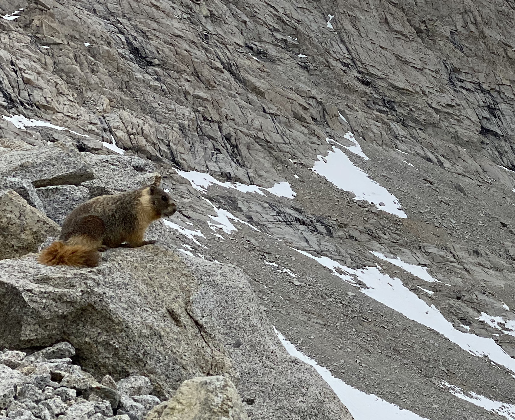
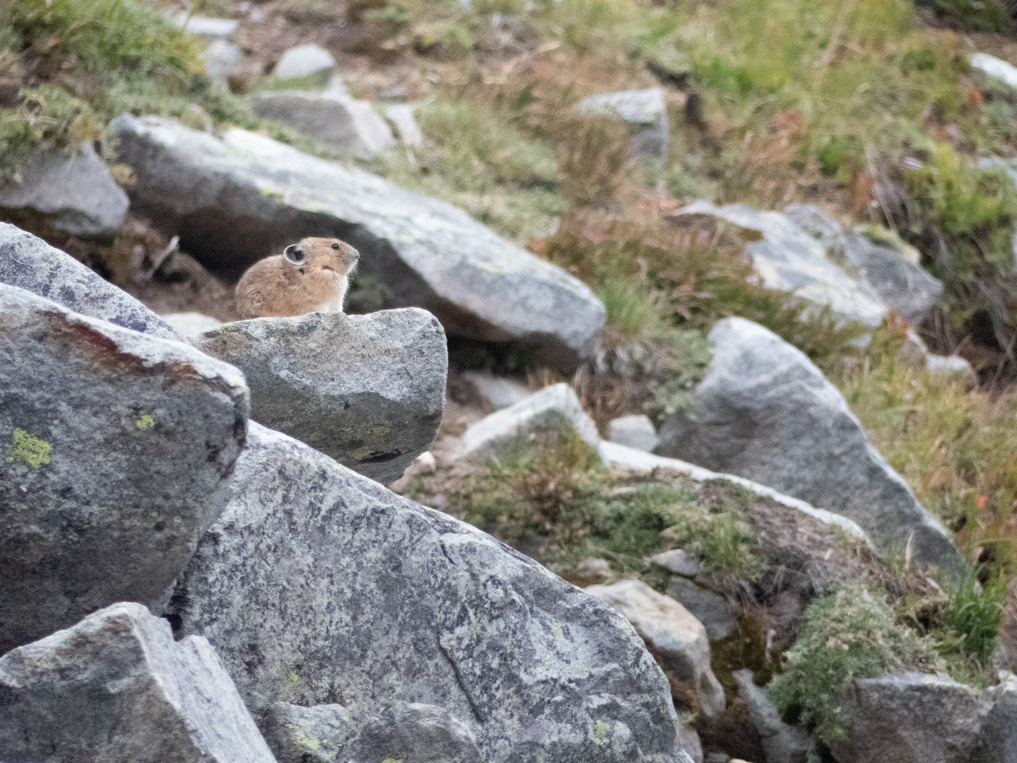
I will let my pictures do the talking to show the 90-mile section from Rainy Pass to the terminus and then back to Harts Pass. I’m also enabling the comments feature on the blog for the first time since I can now respond in a timely manner. I plan to write several other blog posts on topics that span the entire trail, such as what I’ve learned about gear, food, and reflections about the transformative nature of walking. Please feel free to share your observations, questions, or suggestions for future posts in the comments.

I have so appreciated your support by listening to my journey. This blog has helped me to reflect on my experience and put it into words. It is like a photographer looking through the lens and seeing more than they would have otherwise. I never intended to make this trip into something, I just wanted to hike. It led me to the advice of Parker Palmer in his book, Let Your Life Speak. In this beautiful little book, he asks us to look inside to see our place in the grand and magnificent universe we enjoy.

I look forward to seeing you down the trail.

The group of PCT thru-hikers celebrating together at the northern terminus. They, and the dozens of other hikers I shared the trail with, enriched and supported me in innumerable ways.
It had rained most of the night at Rainy Pass, but the storm eased as I hiked through the cloud layer.
Before starting from Rainy Pass,  Pleasure-Way and I saw Stud Muffin, Green Man, and Shepherd starting their hike. Pleasure-Way offered blueberry muffins and a flask with rye whiskey for their celebration in three days. By the way, hiking kilts are pretty popular as an alternative to rain pants.
The sun came out on the second day. I took this photo as I climbed from my campsite on Glacier Pass to Tatie Peak.
I saw two female grouse next to the trail on the second day. My son, Scott, and his wife, Katie, told me that seeing a grouse in the wild is a rare treat. I had heard the deep thumping mating call of the male grouse since the Sierra but had never seen one. These birds were so calm, almost soulful, as they watched me pass.
On the third day, I started hiking in the dark to get to the terminus and back. The dew was slowly losing its grip on Rock Pass as I hiked past at 5:30 am.
Sunrise on the third day as I continued to climb the ridges to get to the terminus.
Three months earlier, I dreamed about doing a tree pose at the northern terminus. The cadre celebrating together supported me with catcalls and whoops as I gave it my best shot. The border is the opposite of a wall – it is a narrow clear-cut running through the forest. I am the only tree standing as you can see the clear-cut extending off into the distance behind me.
Pleasure-Way alerted me that the earlier rain forecast had become more severe for the hike out. The clouds told the same story as we hiked back to camp.
We woke on day four in a cloud as we started our last 15 miles of the journey. Thankfully, it eased during the day but came on strong after driving out of Harts Pass. The road into Harts Pass is not for the timid, with 10 miles of cliffs over a road that deserves a 4WD.
Our successful cadre of thru-hikers, meeting family and waiting for transportation out of Harts Pass.
Categories
Hiking the PCT

The Elusive Glacier Peak

I just completed the amazing and challenging Glacier Peak Wilderness section of the PCT. In six days, I covered 127-miles from Stevens Pass to Rainy Pass with 38K feet of climbing. There is a lot to unpack from my past and current attempt to enjoy the elusive Glacier Peak.

The first attempt was back in college organized by my brother, Bill. The three-day trip was to enter from the west then climb up one of the ridges to enjoy a view of Glacier Peak in all its splendor. We entered via a lush forest trail on the first day before climbing the ridge. We were caught in a torrent so heavy that it flooded our tent. It was so bad that the mice decided to shelter in our tent and raid our food. I remember six people covered in mud trying to dig drainage ditches, fend off mice, and stay warm. Defeated but not dejected, we exited and found other ways to spend our 3-day weekend. I wrote that trip off to inexperience, bad gear, and bad luck.

The second attempt was on my shoulders, leading my family into a similar hike to view the magnificent Glacier Peak from a ridge to the west. The results were the same; we climbed, were destroyed by a rainstorm, and exited with never a glimpse of the mythical peak. This disaster was entirely on me as I chose to ignore the weather report and advice from the ranger at Darrington.

It is only reasonable that my third attempt to hike near Glacier Peak made me nervous. Upon leaving Stevens Pass and climbing the ridges from the south, I was amazed to take pictures of what I thought might just be a legend. However, after climbing Red’s Pass and dropping into a river valley, Glacier Peak disappeared once again, shrouded in smoke from a fire. That set the tone for six days of massive climbs up and down the river valleys surrounding Glacier Peak with glimpsing views through the smoke. Early on, I committed to returning to this magnificent area a fourth time to explore without the threat of fires.

I now have a much clearer picture of both the beauty and the difficulty of the North Cascades. The glacial peaks (Washington has 186 named glaciers versus Oregon 35 and California 20) remind me of the Sierra and the Alps. The 3,500-foot descents and climbs traverse thickly forested river valleys, dense underbrush, and open scree fields. I swam in two glacier-tinted lakes and felt every cell shout, hell yes. I saw plenty of bear scat and heard elk bugle at sunset. I have not backpacked in Alaska, but one thru-hiker made that comparison. The challenges mainly came from the relentless climbs, the bugs, and staying cool during another heatwave. Hikers don’t mention the mosquitos in these parts because they are hardly noticed amongst the swarming small biting flies and the Imperial-Trooper-sized deer flies. Within two days, I was at my wit’s end.

On the third morning, I sent Pleasure-Way a message on my Garmin saying I felt like stopping. She wrote back, “hang in there; you got this.” I met Endless and QB, two triple crown hikers from Boston, who provided some much-needed support. “We are being tested; you got this.” I can’t tell you how much the phrase “you got this” helps from family, friends, and fellow hikers. It may sound like a two-bit cheer, but it sure does the job. “You” is speaking to the many layers of self that have walked this journey with me. “got this” is an affirmation that I have developed the body, mind, and practices to finish this hike. It is hard to put into words how important your support is.

I have 61 miles and 16.3 K feet of climbing to reach the border. I will then turn around and hike 30 miles back to Hart’s Pass. See you on the other side.

I have visited many wilderness areas on this hike. This sign sent a shiver down my spine.
I had to pull out my map to confirm that this was the elusive Glacier Peak.
The climb up Red’s Pass gave me the first glimpse of the four additional passes ahead.
You can barely make out Glacier Peak in this photo. Depending on the ever-changing smoke and light, it would fade in and out over the next four days.
I faced a dangerous river crossing early on my third day when I felt like quitting. I wrote the following Haiku, and this river crossing brought me back to the present moment.
 
The log is the way
My feet lead me through chaos
There is nothing else
The layers and layers of underbrush were beautiful and sometimes claustrophobic.
Swimming in Mica Lake, pure joy and brought my core temperature down instantly.
The view from my campsite on day four; I didn’t even know these mountains were there when I hiked in through the smoke and fading light.
Navigating around blow-down trees is hard enough. In Washington, they can be the size of a house.
Cooler weather and even some showers came in on day six; what a relief.
Categories
Hiking the PCT

Big Week

Thru-hiking like life
brings toil and uncertainty
to ask who am I?
Ribs

I am writing from the comfort of a motel in Mammoth Lakes. I came off the trail today after the most physically challenging week so far with a profound appreciation of the scenic beauty and the responsibility we assume when thru-hiking. In seven days I covered 123 miles with 32K elevation gain from eight passes averaging over 11K feet.

I was joined by my nephew, Peter, an experienced Sierra climber and back country skier. His presence boosted my confidence to navigate the three highest passes with snow.

Kearsarge Pass, at nearly 12K feet, is required just to get back to the PCT
Glen Pass, our second 12K pass of the first day, required several steep snow field traverses – not a big deal for Peter but I fell several times
Looking back at Glen Pass from the Rae Lakes

I could have written a nice post titled “Big Day – The Sequel” after two major climbs on the first day. But we were just getting started. Every day we climbed as quickly as possible to summit the next pass before the snow got too soft or possible afternoon thunderstorms materialized. We then dropped 3K feet to the valley floor to camp before starting the sequence again. It makes me tired just listing our Big Week itinerary.

  • Day 1: Kearsarge 12K and Glen 12K
  • Day 2: Pinchot 12K
  • Day 3: Mather 12K
  • Day 4: Muir 12K
  • Day 5: Selden 11K
  • Day 6: Silver 11K
  • Day 7: Mammoth 10K
We met him at first light of day 2 sharing the river valley, the first of many deer over the week
Pinchot Pass featured the barren moonscape of the southern Sierra
Looking back from Mather to Pinchot Pass showed our day 3 work

Peter and I were most concerned about Muir Pass because of the snow depth. It was the most scenic section of the PCT so far. The intense azure blue of the lakes and sky radiated off the snow and ice.

Peter leads the way up Muir Pass
The John Muir shelter, built in 1930, saves lives when storms close in on this highly exposed landscape
Wanda Lake, north of Muir Pass, defines radiance
The ice flow moved with the wind, I had to peel my eyes away lest I would still be sitting there

The descent from Muir took us into the magical Evolution Valley. I have tried to hike this section for years but permits and fires have intervened. It is the transition from the barren Sierra peaks to the lush forests that stretch from valley floor to alpine lakes.

We shared our campsite view with the residents of Evolution Valley

The constant pounding of the descents took a toll on Peter. He dealt with a daily barrage of blisters but then he re-activated knee issues that quickly escalated. He decided to hike 16 miles out rather than continue 45 more miles and risk an evacuation. It was a hard decision but demonstrated the most important responsibility we have in remote wilderness situations – know your limits at every moment. Later we concluded the issue was likely using climbing approach shoes. Every thru-hiker tweaks their gear, food, and body care over weeks and months – Peter had five days.

Foot care at its best

I continued north to finish the last three passes and 45 miles. I had hiked this section with Jenessa in 2017 so it was fun to experience the trail again and remember the trip that inspired me to hike the PCT.

Silver Pass was number seven and a crazy day of climbing
After a full meal, I decided to take on a mammoth mud pie. You’re damn right I finished it with an audience at the next table.
Categories
Hiking the PCT

Scott: Wildlife in the South Sierra

A few weeks ago, I was lucky enough to get on the trail with Ribs for a beautiful stretch of California. Starting at Kennedy Meadows and finishing up at Kearsarge Pass (read all about it if you missed it). The trip was a great endnote for my year-plus of COVID-19: It kicked off with a final vaccine dose, my first air travel in over a year, and hugs from family members. But it also was an opportunity to put to use while backpacking a past-time I picked up during lockdown: Bird Watching.

Bird Watching and thru-hiking seem like an uneasy pair; often, you get the best results birding by standing still and walking very, very slowly, anathema to a thru-hiker who’d rather be on their feet or sleeping. However, just by being up for almost the whole day – you’re given an opportunity to observe birds and critters as they go about their days and see how their rhythms match or miss that of a hiker.

Along our 110 mile hike, we spotted several birds (and other critters) that I often see around Portland – Juncos, Chickadees, Crows, Chipmunks – but I wanted to share a few of my favorites that I notice along the trail:

Cliff Swallow

Cliff Swallow | Audubon Field Guide
Photo Credit: Audubon Society

Even before we hit the trail, we were bumping into Cliff Swallows as we boondocked at Kennedy Meadows, and they also greeted us at our first camping site along the S Fork of the Kern River. These little birds will make nests alongside the edge of cliffs (or bridges in these cases) made of mud and swarm into huge flocks to catch bugs. As the sunset on the first night, Ribs and I watched them fill up the sky. These little guys tended to come out when we were making or breaking camp.

Clark’s Nutcracker

Clark's Nutcracker Identification, All About Birds, Cornell Lab of  Ornithology
Photo Credit: All About Birds

After we’d hit the trail and got moving through a sparse forest of ancient and sometimes fire-scarred sequoias – we’d often spot these flitting in between the trees, usually at the edge of our vision. They didn’t tend to call out, but you’d see them watching us along the trail. A relative of crows and jays – they tended to be a bit shy – staying active throughout the day on our hike, only disappearing around late afternoon.

Townsend’s Solitaire

Townsend's Solitaire Adult
Photo Credit: All About Birds

As we ascended higher into the Sierra – camping at 7000 ft, then 9000, then never coming below 10,000 – I noticed a very complex bird call that would start in the mid-morning and then reemerge in the later evening. It took me a few days to finally spot the culprit – this small gray bird that would hang out on shrubs. It’s apparently a huge fan of juniper and likes to hang out in the higher elevations during the breeding months.

Gray-crowned Rosy Finch

Gray-crowned Rosy-Finch Identification, All About Birds, Cornell Lab of  Ornithology
Photo Credit: All About Birds

We climbed Mt Whitney at sunrise on the fifth day and hunkered down to eat our breakfast from the wind. One of these little fellas took our presence as an open invitation to crash our party – coming very close to our sleeping bags and oatmeal. Despite our protestations – it persisted by dodging and weaving around us to gain access to our treats. Another high-altitude forager, these birds can often be found on snowfields foraging for seeds. Stealing food from altitude-addled climbers does seem much easier by comparison.

Yellow-bellied Marmot

A marmot surveys Forester Pass, Photo Credit: Me

Of course, we encountered many more critters than just birds – from our first day on the trail, we started to see bushy tails hard at work just off or on the trails. They’re probably busy preparing for mating season – marmots are polygynous with the males attracting several females – and so had a lot to get ready. One surprise was the silent treatment we received from these Marmots – on a previous hike late in the season near Washington’s Goat Rocks (1500 miles in Rib’s future), they would stare us down and emit a high pitch bark to warn their burrow-mates.

Pika

Pika on Mt Rainer, Photo Credit: Me

Speaking of suddenly quiet, we were also surprised by the stony silence we received from Forester Pass’s Pika population. These high-elevation rodents (which we also encountered in the Goat Rocks) are always on the lookout and will squeak to warn the colony when outsiders trespass on the rocky scree where they make their burrows. We only encountered a singular Pika who maybe could tell from our micro-spikes and hurried pace that we wouldn’t be staying long at 13,000 ft as the snow started to fall.

Coyotes

Be cautious of Lake Tahoe's wily coyotes – Toree's Stories | SierraSun.com
Photo Credit: Sierra Sun

Coyotes were with us for almost our whole journey: from the road up to Kennedy Meadows to our first morning on the trail – their omnipresent prints and scat attests that the Sierra are their mountains. I had been feeling left out after both my parents had spotted their own until I finally bumped into one at Guitar Lake on the way down from Mt Whitney. The large coyote ran along the trail, towards but then away from me, pausing when he was far enough along to give me a once-over before a full-body shake. “Eh, not worth it,” it seemed to taunt with that shake before climbing up the valley towards an easier lunch.

The South Sierra is a landscape of contrast – granite peaks tower over some of the driest and lowest parts of North America. That elevation and rain shadow catches moisture as it moves across the continent, cultivating a lush landscape where life – sequoia, juniper, and mountain meadows – can thrive. And it was a great joy to get to hike through it all and take it in.

Categories
Hiking the PCT

Cascading

In our attempt to hike the entire PCT this summer, we have been jumping north to hike short sections of the trail while waiting for the snow to melt in the Sierra. These disjointed sections were, in fact, a wonderful introduction to the Cascade Mountains. I hiked 214 miles from Belden to Castle Crags State Park on I-5 in four hikes over nine days through the Mt. Lassen and Mt. Shasta National Forests.

This sign announcing entry into the Cascades Range is 400 PCT miles from the Oregon border.

In my initial attempt to hike up north three weeks ago, Home Alone, I didn’t see many people but did find signs of bears and plenty of snow. These themes continued as I encountered only five parties backpacking over the entire distance. It was unnerving at first, but I came to appreciate the solitude. Signs of bears continued, and I spent time trying to understand their activities – I never saw one, which is always the goal. And, yes, the snow found new ways to tease and torment, reminding me that I am simply a visitor in nature’s house.

Looking 30 miles south at Mt. Lassen from Hat Creek Rim
Looking 100 miles north at Mt. Shasta from Hat Creek Rim
A recent bear print near Mt. Lassen
Bear scat full of Juniper berries inspired me to alert them near Juniper groves.

The next time we jumped north to avoid a snowstorm in the Sierra came after The Amazing South Sierra. I began by hiking a 46-mile section near Mt. Lassen, thinking that the worst of the snow would hit in the Sierra. I stayed with Pleasure-Way after completing that section and was surprised to find four inches of snow at our campsite the next day and likely six to eight inches covering my planned route. We decided to make a quick dash home and found that the snow stretched far north into Oregon at PCT trail elevations.

Fresh snow on May 20 at Old Station near Mt. Lassen 2,500 feet below where I was hiking the day before
The snow highlighted the magnificent trees in the Mt. Lassen National Park

We returned after a few days to complete the section. I will leave you with some visual and poetic images of the southern Cascade Mountains. I look forward to hiking the remaining 1,150 miles of the Cascades after I complete the Sierra.

The Sugar Pine trees were the winner in the pine cone category, with a close second going to the Gray Pines.
My campsite at sunrise looking down on Lake Almanor
Snow plants signal the start of spring, bursting forth from snowbanks
Emerging from snow
everything given freely
sweet nectar of life.
              Ribs

Categories
Hiking the PCT

Home Alone

Part of our PCT plan is to use my wife’s incredible support, the ultimate trail angel, to leap forward and backward to optimize the chance of finishing the trail in one year. There are many reasons this helps from avoiding snow, fires, and dealing with injuries. The time window is short for finishing the desert section before the summer heat and the northern Cascades before the snowfalls. We successfully lept backward to complete the San Jacinto section earlier, so what could go wrong?

This week we lept 700 miles forward to start an 83 mile, three-day hike beginning at Burney Falls, north of Mt. Lassen, and ending at Castle Crags on I-5. It was time to test our approach to find terrain with less snow. I immediately felt at home, entering a deep, lush forest, and I did not see another person for 65 miles. I could make out one pair of shoe prints from this season, maybe two weeks earlier.

The lush forest was like coming home.
My camp on the first night after 25 miles – home alone
Mt. Shasta from my campsite

COVID deprived us of our holiday traditions, so we experimented with a few new ones. One was to watch the classic holiday movie Home Alone. That first day on the trail felt a bit like Macaulay Culkin’s first night celebrating after realizing that he had the house to himself. Similarly, it is the second day when the real story begins. My experience shifted from a stroll through the forest to a 13-hour orienteering drill through deep snow. The faint shoe prints vanished early on, replaced by deer and bear prints. I could not figure out why there were 12-foot drifts and miles of snowfields when the snow reports showed otherwise. I put those theoretical questions aside and got serious about using all my navigation tools (apps, maps, compass, and GPS) to find the most efficient route.

Black bear prints and scat were frequent, so I used my whistle to alert them of my presence.
I hiked four hours through deep snow – sometimes, the most accessible trail is straight up.
The views of Mt. Shasta continued to inspire me.

I finally broke free of the snowfields and discovered the answer to my question. I was hiking through a north-facing basin that funneled the weather from several mountains leading to deep snowdrifts. I did not see another section with this level of variation. I hiked hard once I cleared the snow basin and camped after covering 24 miles. I was exhausted but also felt good about how I worked through my unexpected challenges.

I solved the mystery once I reached the ridge.

The third day was like the triumphant coming home party that the wiser and more confident Macaulay Culkin experienced. I hiked 34 miles through beautiful old-growth forests and completely lost myself in the experience. My wonderful trail angel was there at I-5 with trays of food, including fried chicken, salad, potato wedges, fruit, cookies, and I ate it all. I am so fortunate to have a chance to immerse myself in this experience with such unconditional support.

My reward was an amazing 34-mile day through old-growth forests.