I am sitting in a peaceful campground outside of Julian, California, enjoying my first “zero.” For thru-hikers, a zero is a day off, meaning zero miles hiked that day. I have planned five zeros over the first 700 miles, so these are mighty precious. Since Alesia is supporting me in our van, I have been able to stay in the vehicle at some road crossings. It has helped me push the mileage and recover more effectively, an incredible advantage as I get myself into PCT shape.
Crossing the 100-mile mark
Alesia’s family knows how to read and interpret box scores. I can’t do either – but here is my PCT box score for the 1st of 26 segments. In five days, I covered 109 miles with 12K feet of climbing. All 26 segments comprise 2650 miles and 390K feet of climbing. The home team is off to a great start. Other statistics include bliss-meter pegged at 110%, 0 injuries, 0 blisters, 0 sunburns, and 0 rattlesnake bites. I went from COVID-19 zoom-zombie to a 10 hour per day hiker, which just shouldn’t happen on paper. I ended up doing this segment one day faster than planned. Here are a few photos from the journey so far. I fell in love with the rugged and vast terrain from Campo to Warner Springs.
Looking back at Scissors Crossing, where we boondocked.An amazing meadow with wildflowers near Warner Springs.I crossed this meadow near sunset.Eagle Rock near Warner Springs.Bliss meter pegged, even as I finished a 32-mile day.
For the first few days on the trail, I felt like I was setting the agenda. That bubble burst this week. After ten days and 200+ miles, it is clear that the trail and everything surrounding it provide the experience, and I am here to learn (one way or another). My lesson so far is to connect with what is, don’t add my delusional views, whether blissful, angry, or needy. Then I must decide what I will make of it. I will be relearning this lesson every day, and I sense there are many chapters to come.
Crossing a welcoming meadow north of Warner springs.
Segment 2 started with two hot days, little water, and questionable sources. With 10K feet of climbing, I began to get angry, thirsty, and hungry. All these growing obsessions were neither accurate nor helpful. The bliss-meter took a nosedive. I found refuge at Mike’s Place, a renowned oasis in the Lost Valley of all places. Never has a tortilla filled with a hot dog slathered in refried beans tasted so good.
This was one of the better water sources.Good strumming and conversation at Mike’s Place.Encouragement from previous travelers.
I climbed the San Jacinto mountains for the next three days, known as one of the PCT’s most challenging and dangerous sections due to the exposure and volatile weather. On the first day, I faced 60-mile hour winds and on the second deep snow. It is beautiful, but every few steps, I post-holed waist-deep, risking injury. I decided to detour around the final 30 miles as an even stronger wind storm approached. My learning was put to the test as my ego argued against all evidence to fight through the conditions and my fatigue. I chose to learn and hike another day. Well, now, my trail angel just arrived.
Climbing into San Jacinto.I started to post-hole on every step and quickly lost the trail. Following other tracks only made it worse as they also wandered through the basin.
In an earlier blog, I shared that I had to pull out of the last 30 miles of the San Jacinto section of the PCT due to heavy snow. Within a few days, Alesia and I were scheming on how to get back to complete this section. I did, and it was a big day. In my hiking vocabulary, a big day is just beyond reach, possible, but it calls forth more of everything; more focus, more energy, more endurance with a large splash of attitude.
5:30 AM start on Devil’s Slide trail
The goal was to hike back to Saddle Junction where I left the PCT. The Devil’s Slide trail was the shortest route at 2.5 miles but added 1,700 feet of climbing to the front end of my hike. The starting temperature was 37 degrees, and it was below freezing on San Jacinto.
Early light climbing to Saddle Junction
The climb was beautiful as the morning light filtered in from the east. I quickly climbed from 6,400 feet to Saddle Junction at 8,100 feet.
A look back to Tahquitz Peak
Once on the PCT, the climb continued up to 9,000 feet. I felt that this challenge was going much easier than expected. The morning had a brisk and brilliant feel, and my legs and lungs were more than excited to push forward.
So much for trail reports.
The wheels started to come off as quickly as turning a bend on the trail. The deep snow returned and was not at all what I had heard from other hikers. I spent the next eight miles navigating snow on the ascent and descent. Fortunately, the cold temperatures over the previous days kept me from sinking deep into the snow (post-holing). I put micro-spikes onto my hiking shoes to gain some traction. Nonetheless, it was exhausting and my pace slowed to the point that I assumed I would need to shelter overnight.
Looking down at I-10, my destination
After descending several thousand feet, I finally left the snow behind. I had only covered 13 miles in seven hours. Looking north, I could see my destination 7,500 feet below and 20 miles away. It seemed out of reach, but thinking about what is possible is much less effective than seeing what is possible – one step at a time.
Looking back at San Jacinto from the north
The descent took me down over 15 miles of switchbacks from the lush forest to a barren desert. San Jacinto’s presence was apparent around every corner. My feet and legs begged for a break from the pounding, but the remaining miles started to look doable.
A wild place to admire
I covered 33 miles, climbed 6,700 feet, and descended 12,700 feet in under 14 hours. San Jacinto is a small wilderness by western standards, but it is wild and dangerous. I had read reports and watched videos of this hike, and it was hard for me to grasp why this area has taken the lives of PCT hikers and locals. I am so glad to have seen it first hand, and I admire it as a precious wild place.
Hello again. I have been busy at my day job, which involves a green 38-liter backpack and two hiking poles. Today is my seventh day in a row with two more left to Kennedy Meadows, the doorstep of the Sierra. As I type this on my phone, I find myself at mile 658 and at 8,000 feet.
One of the most anticipated (or dreaded) sections of the PCT is the Mojave desert crossing north of LA. It is only 60 miles, but the temperatures often require carrying large quantities of water and hiking at night. I hiked with a rainstorm closing in that dropped snow in the surrounding foothills. I will let my photos tell the story.
The Mojave trek starts at hikertown. This funky enclave is a microcosm of trail life.The first leg follows the California aqueduct teasing anyone who didn’t bring enough water.The next 20 miles follow the LA aqueduct.The storm closing in at dusk.I camped on a wind farm under a full moon.Hundreds of 3MW windmills created a surreal light and soundscape.A morning rainbow and cold wind greeted me on the second day, but the rain did not return.I hiked through the wind farm for over 30 miles.
I am dedicating this post to my new dear friend – the Southern California section of the PCT. I completed the hike to Kennedy Meadows yesterday in style with a 31-mile day driven by my trail family as we raced to spend an evening at Grumpy Bears, an oasis for hikers preparing to enter the Sierra Nevada Mountains. It was a fitting end to a hike through entirely new terrain and experiences. If the hike ended here, I would have stories and friends for a lifetime. My thru-hiker bug is excited to turn the page to see what is next.
My reward for pushing hard to get to Grumpy Bears (I love this place).
I completed 700 miles in 30 hiking days, or 23 miles a day. I took five days off (zeros) for an average of 20 miles a day in total. 700 miles is 26% of the total PCT mileage, and I have climbed around 140K feet or 28% of the total. These numbers don’t mean anything on the trail because every mile, every vista, and every step brings something new. I have never had such an extended immersive experience.
Crossing 700 miles after a wild last day.
Even though I have backpacked for decades, thru-hiking is relatively new to me. Thru-hiking is different in that the enjoyment comes from the journey, not from reaching a destination. You carry everything on your back for the entire day, so simplicity is key.
Today I met Yogi, a woman that opened the door to thru-hiking. Yogi, or Jackie McDonnell, has hiked the Appalachian Trail twice, Pacific Crest Trail 3.5 times, the Continental Divide Trail twice, and the Colorado Trail once. Her books made thru-hiking accessible. I was starstruck when I discovered she and her partner own the Triple Crown Outfitters re-supply depot at Kennedy Meadows. I have learned so much from Yogi, and she is my meta trail angel.
Yogi giving me the PCT 2021 Class bandana.
I will leave you with a few photos of the last section of the trail leading from the Mojave Desert into the Sierra. I am jumping north for a week before starting the Southern Sierra section with my son Scott. Thanks for joining me and feel free to share this blog with others. See you down the trail.
Hiking into Kennedy Meadows.Sawtooth Peak reminds me of my days hiking in Idaho.A morning climb from Spanish Needle Creek.Crossing Walker Pass at 6 AM to climb Mt. Jenkins.Dusk setting on Ridgecrest.
Part of our PCT plan is to use my wife’s incredible support, the ultimate trail angel, to leap forward and backward to optimize the chance of finishing the trail in one year. There are many reasons this helps from avoiding snow, fires, and dealing with injuries. The time window is short for finishing the desert section before the summer heat and the northern Cascades before the snowfalls. We successfully lept backward to complete the San Jacinto section earlier, so what could go wrong?
This week we lept 700 miles forward to start an 83 mile, three-day hike beginning at Burney Falls, north of Mt. Lassen, and ending at Castle Crags on I-5. It was time to test our approach to find terrain with less snow. I immediately felt at home, entering a deep, lush forest, and I did not see another person for 65 miles. I could make out one pair of shoe prints from this season, maybe two weeks earlier.
The lush forest was like coming home. My camp on the first night after 25 miles – home aloneMt. Shasta from my campsite
COVID deprived us of our holiday traditions, so we experimented with a few new ones. One was to watch the classic holiday movie Home Alone. That first day on the trail felt a bit like Macaulay Culkin’s first night celebrating after realizing that he had the house to himself. Similarly, it is the second day when the real story begins. My experience shifted from a stroll through the forest to a 13-hour orienteering drill through deep snow. The faint shoe prints vanished early on, replaced by deer and bear prints. I could not figure out why there were 12-foot drifts and miles of snowfields when the snow reports showed otherwise. I put those theoretical questions aside and got serious about using all my navigation tools (apps, maps, compass, and GPS) to find the most efficient route.
Black bear prints and scat were frequent, so I used my whistle to alert them of my presence.I hiked four hours through deep snow – sometimes, the most accessible trail is straight up.The views of Mt. Shasta continued to inspire me.
I finally broke free of the snowfields and discovered the answer to my question. I was hiking through a north-facing basin that funneled the weather from several mountains leading to deep snowdrifts. I did not see another section with this level of variation. I hiked hard once I cleared the snow basin and camped after covering 24 miles. I was exhausted but also felt good about how I worked through my unexpected challenges.
I solved the mystery once I reached the ridge.
The third day was like the triumphant coming home party that the wiser and more confident Macaulay Culkin experienced. I hiked 34 miles through beautiful old-growth forests and completely lost myself in the experience. My wonderful trail angel was there at I-5 with trays of food, including fried chicken, salad, potato wedges, fruit, cookies, and I ate it all. I am so fortunate to have a chance to immerse myself in this experience with such unconditional support.
My reward was an amazing 34-mile day through old-growth forests.
I am sending this post from the highest place in the continental US. My son, Scott, and I started our climb at 2 AM and arrived to watch the sunrise over Death Valley. Scott joined me at Kennedy Meadows, and we have hiked 75 miles and climbed nearly 20K feet. Summiting Whitney was worth every step.
Getting Ready – approaching Mt. Whitney from the east
We hiked into Crabtree Meadows yesterday to prepare for the 7.8 mile, 4K foot climb.
Looking for the trail is a team effort.
We left camp at 2 AM and worked together to find the trail with our headlamps.
Watching the sunrise over Death Valley.We used sleeping bags to wait for the sun.At the top of the Continental US.
Exhaling crystals
heart pounds like a pile driver
Mt. Whitney awaits.
                        Ribs
This is my fifth trip into the Sierra Nevada mountain range. It stretches 400 miles long and about 70 miles wide for a mind-boggling 40M square miles. I got to take the journey through 110 miles of the southern end of this magical place with my son Scott. The scope of this gem is hard to fathom, and the photos shared might blur together. But each and every valley or vista we traveled called for deeper exploration.
One request frequently faced by PCT hikers is for family or friends to join them on a portion of the hike. This often ends badly as the finely tuned bodies and packs required for thru-hiking meet their guests’ not so finely tuned bodies and packs. I had no such concerns about Scott, given his penchant for ultra-marathons and other endurance events. But even he admitted that the 30-year age advantage did not fully account for my 750 miles on the trail. He did, however, make up the difference by the time we reached Mt. Whitney and left me hiking in the dark.
The trip started frantically picking up Scott in Reno, driving six hours to Kennedy Meadows, and sorting gear and food for a week. We got a late start, and neither of us was in very high spirits as the mid-day heat and reality of 110 miles loomed ahead.
Sorting our gear and food for seven daysLeaving Kennedy Meadows with a hot sun and monstrous packs
The first two days were through the transition zone of high desert to alpine abundance. We had to carry water to last a full day, given the infrequent opportunities to fill.
The first day ended at the South Kern River – a morale boosterOur campsite on the second day provided views of what was to come
By day three, we kicked into gear to start climbing from 6K feet into the 10K – 14K feet elevations that would be our new home. The living systems were changing before our eyes.
The Bristlecone Pine forests greeted us at every turnWe camped at an alpine lake at over 11K feet
Days four through six included epic adventures from climbing Mt. Whitney (14.5K ft) before sunrise to hiking through mountain plains that looked like Peru and climbing over Forester Pass (13.2K ft) with a snowstorm closing in. The physicality of the place consumed me – this was tough work. But that faded rapidly as the majesty fueled me. I could spend a week exploring any one of the dozens of mountain basins we saw. This place is a must-see if you lose yourself in wild places.
On top of it all on Mt. WhitneyLooking back at Mt. Whitney, now a tiny bump on the horizonThe mountain plain stretched for miles as we approached Forester PassSummiting Forester Pass (13.2K ft) required scrambling over a cornice at the topWe had miles of snow to contend with on the north side of Forester PassOur final look back into this fantastic area as we left through Kearsarge Pass
In our attempt to hike the entire PCT this summer, we have been jumping north to hike short sections of the trail while waiting for the snow to melt in the Sierra. These disjointed sections were, in fact, a wonderful introduction to the Cascade Mountains. I hiked 214 miles from Belden to Castle Crags State Park on I-5 in four hikes over nine days through the Mt. Lassen and Mt. Shasta National Forests.
This sign announcing entry into the Cascades Range is 400 PCT miles from the Oregon border.
In my initial attempt to hike up north three weeks ago, Home Alone, I didn’t see many people but did find signs of bears and plenty of snow. These themes continued as I encountered only five parties backpacking over the entire distance. It was unnerving at first, but I came to appreciate the solitude. Signs of bears continued, and I spent time trying to understand their activities – I never saw one, which is always the goal. And, yes, the snow found new ways to tease and torment, reminding me that I am simply a visitor in nature’s house.
Looking 30 miles south at Mt. Lassen from Hat Creek Rim Looking 100 miles north at Mt. Shasta from Hat Creek RimA recent bear print near Mt. LassenBear scat full of Juniper berries inspired me to alert them near Juniper groves.
The next time we jumped north to avoid a snowstorm in the Sierra came after The Amazing South Sierra. I began by hiking a 46-mile section near Mt. Lassen, thinking that the worst of the snow would hit in the Sierra. I stayed with Pleasure-Way after completing that section and was surprised to find four inches of snow at our campsite the next day and likely six to eight inches covering my planned route. We decided to make a quick dash home and found that the snow stretched far north into Oregon at PCT trail elevations.
Fresh snow on May 20 at Old Station near Mt. Lassen 2,500 feet below where I was hiking the day beforeThe snow highlighted the magnificent trees in the Mt. Lassen National Park
We returned after a few days to complete the section. I will leave you with some visual and poetic images of the southern Cascade Mountains. I look forward to hiking the remaining 1,150 miles of the Cascades after I complete the Sierra.
The Sugar Pine trees were the winner in the pine cone category, with a close second going to the Gray Pines.My campsite at sunrise looking down on Lake AlmanorSnow plants signal the start of spring, bursting forth from snowbanks
Emerging from snow
everything given freely
sweet nectar of life.
              Ribs
A few weeks ago, I was lucky enough to get on the trail with Ribs for a beautiful stretch of California. Starting at Kennedy Meadows and finishing up at Kearsarge Pass (read all about it if you missed it). The trip was a great endnote for my year-plus of COVID-19: It kicked off with a final vaccine dose, my first air travel in over a year, and hugs from family members. But it also was an opportunity to put to use while backpacking a past-time I picked up during lockdown: Bird Watching.
Bird Watching and thru-hiking seem like an uneasy pair; often, you get the best results birding by standing still and walking very, very slowly, anathema to a thru-hiker who’d rather be on their feet or sleeping. However, just by being up for almost the whole day – you’re given an opportunity to observe birds and critters as they go about their days and see how their rhythms match or miss that of a hiker.
Along our 110 mile hike, we spotted several birds (and other critters) that I often see around Portland – Juncos, Chickadees, Crows, Chipmunks – but I wanted to share a few of my favorites that I notice along the trail:
Even before we hit the trail, we were bumping into Cliff Swallows as we boondocked at Kennedy Meadows, and they also greeted us at our first camping site along the S Fork of the Kern River. These little birds will make nests alongside the edge of cliffs (or bridges in these cases) made of mud and swarm into huge flocks to catch bugs. As the sunset on the first night, Ribs and I watched them fill up the sky. These little guys tended to come out when we were making or breaking camp.
After we’d hit the trail and got moving through a sparse forest of ancient and sometimes fire-scarred sequoias – we’d often spot these flitting in between the trees, usually at the edge of our vision. They didn’t tend to call out, but you’d see them watching us along the trail. A relative of crows and jays – they tended to be a bit shy – staying active throughout the day on our hike, only disappearing around late afternoon.
As we ascended higher into the Sierra – camping at 7000 ft, then 9000, then never coming below 10,000 – I noticed a very complex bird call that would start in the mid-morning and then reemerge in the later evening. It took me a few days to finally spot the culprit – this small gray bird that would hang out on shrubs. It’s apparently a huge fan of juniper and likes to hang out in the higher elevations during the breeding months.
We climbed Mt Whitney at sunrise on the fifth day and hunkered down to eat our breakfast from the wind. One of these little fellas took our presence as an open invitation to crash our party – coming very close to our sleeping bags and oatmeal. Despite our protestations – it persisted by dodging and weaving around us to gain access to our treats. Another high-altitude forager, these birds can often be found on snowfields foraging for seeds. Stealing food from altitude-addled climbers does seem much easier by comparison.
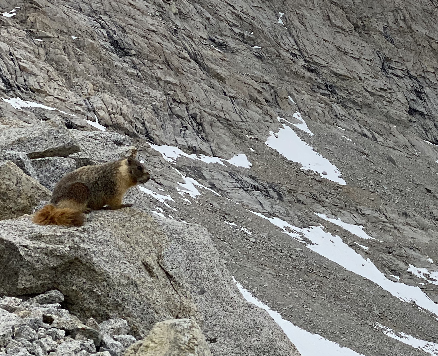
Of course, we encountered many more critters than just birds – from our first day on the trail, we started to see bushy tails hard at work just off or on the trails. They’re probably busy preparing for mating season – marmots are polygynous with the males attracting several females – and so had a lot to get ready. One surprise was the silent treatment we received from these Marmots – on a previous hike late in the season near Washington’s Goat Rocks (1500 miles in Rib’s future), they would stare us down and emit a high pitch bark to warn their burrow-mates.
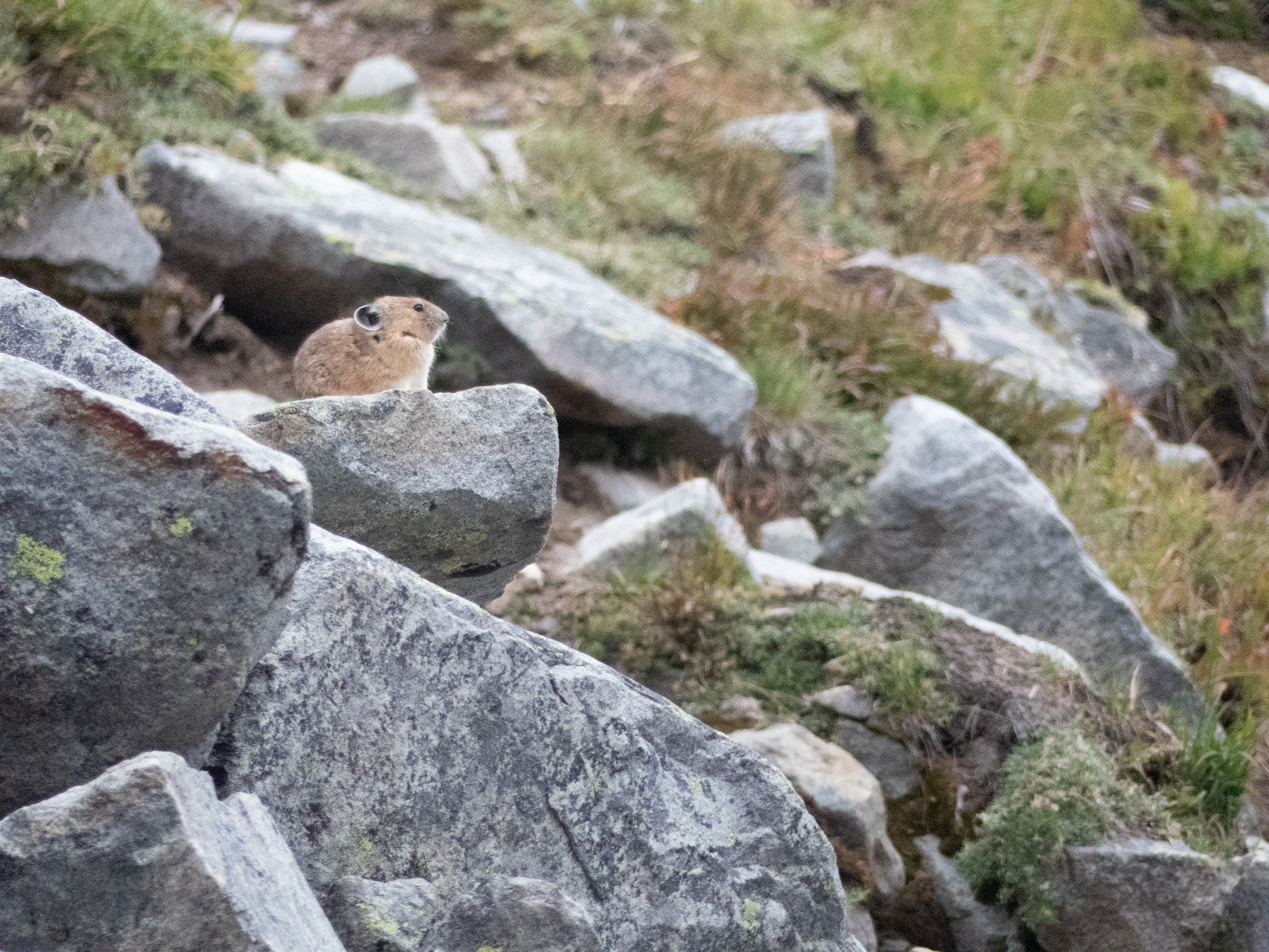
Speaking of suddenly quiet, we were also surprised by the stony silence we received from Forester Pass’s Pika population. These high-elevation rodents (which we also encountered in the Goat Rocks) are always on the lookout and will squeak to warn the colony when outsiders trespass on the rocky scree where they make their burrows. We only encountered a singular Pika who maybe could tell from our micro-spikes and hurried pace that we wouldn’t be staying long at 13,000 ft as the snow started to fall.
Coyotes were with us for almost our whole journey: from the road up to Kennedy Meadows to our first morning on the trail – their omnipresent prints and scat attests that the Sierra are their mountains. I had been feeling left out after both my parents had spotted their own until I finally bumped into one at Guitar Lake on the way down from Mt Whitney. The large coyote ran along the trail, towards but then away from me, pausing when he was far enough along to give me a once-over before a full-body shake. “Eh, not worth it,” it seemed to taunt with that shake before climbing up the valley towards an easier lunch.
The South Sierra is a landscape of contrast – granite peaks tower over some of the driest and lowest parts of North America. That elevation and rain shadow catches moisture as it moves across the continent, cultivating a lush landscape where life – sequoia, juniper, and mountain meadows – can thrive. And it was a great joy to get to hike through it all and take it in.


