Categories
Gear and Food

Gear Head – what to leave in, what to leave out.

Hello trail family – I did not forget you. I have been making my site easier to navigate, so check out the blog categories from the menu and the blog word cloud on the main page to visit the pages that speak to those topics. I am committed to keeping this site alive as some prepare for your thru-hiking adventures next year.

I promised to write a blog about gear in early August while on the trail. Here we are in October, and it is still on my to-do list moving week-for-week. This delay is not just my penchant for procrastination; I discovered that I have a bonified insecurity on the topic of gear. My hangup started before Campo and grew as the pros and bros made conversation about our gear. “What is your base weight? Wow, 15 pounds – good luck with that,” followed by an eye roll. The closest thing I can remember is pulling up to a stoplight back in ’73 next to one of the cool kids in high school. He was driving a candy apple red Pontiac GTO coupe with a beefy 455 HO V8 long-stroke engine. I was in my faded turquoise Toyota Corolla 4-door, 4-cylinder, 75 horsepower looking the other way. Those moments aside, my little car, named Nidwin, did do the job just fine.

Don’t get me wrong; I love gear. It is hard to fathom hiking this trail with the 60+ pound packs full of equipment that didn’t keep hikers as warm, dry, or safe as what is readily available today. After my four-month counseling session, courtesy of the trail, I am ready to rise above my insecurities and share my mistakes so you can avoid mine and make your own. Below is an excel sheet that you can download with my gear list.

Kiki the COVID kitty helping get my gear sorted before leaving for Campo.

Base Weight

Comparing the weight of gear is equivalent to horsepower back in the muscle-car days. And, just like horsepower, there is a lot of gamesmanship (or confusion) on what it means. I found two helpful measures. The first came from an excellent blog on gear by Halfway Anywhere. Halfway provides a valuable summary of top gear, and I used his site extensively. He defines the Big Four as a tent, backpack, sleeping bag, and sleeping pad. Invest in these four items because they are half of your base weight and critical for safety. The second measure, Base Weight, is everything in your pack except consumables (food, water, fuel, toilet paper, etc.). My base weight ranged from 13 to 17.5 pounds, depending on my kit (see below).

There are two problems with obsessing about Base Weight. Andrew Skurka’s blog describes his journey to discovering “stupid light.” Hikers that tout Base Weights as low as 7 pounds are unlikely to be self-sufficient when conditions turn for the worse. The reality of stupid light is that other hikers or rescuers are more likely to need to bail them out. The second issue to consider is your total pack weight when starting a hiking segment. For example, for a six-day section, my total pack weight doubled from 15 to 30 pounds. I needed 2 pounds of food per day, one fuel canister, and I typically carried 2 liters of water. I mention this because many thru-hikers use ultralight packs with little support. They work great at 20 pounds or less but became painful above that. The heaviest carries came in the Sierra with a Pack Weight above 35 pounds for seven days of food, bear canister, warm clothing, ice axe, and microspikes.

Customized Kits

My alternative to going stupid light was customizing my kits for different hiking segments. Changing kits gave me a significant advantage, only possible with Pleasure-Way’s support. In the spreadsheet, you will see five kits across the top: warm segments (1-3 nights, or 4-7 nights), cold segments (1-3 nights, or 4-7 nights), and a snow segment. The table shows how I changed my gear depending on what was coming up next. I recognize other thru-hikers do not have this luxury, but they do ship gear to and from resupply points along the trail for big transitions, like the Sierra.

Setting out on the first seven-day Sierra section. We weighed in above 35 pounds and the smiles are not authentic.
Happier days with my EXOS 38 light pack and kit for a 1-3 day warm hiking section.

The Big Four

TENT: I used the Big Agnes Ultralight Tiger Wall UL2 tent. I have been a fan of Big Agnes for a decade because their gear is light and durable with excellent customer support. The packed weight of the tent is 2.5 pounds, including the footprint. This tent faced wind gusts well over 60 mph on this trip and temperatures in the teens. It also has plenty of room to hang out, store gear, and cook meals. The downside is that nylon absorbs water over multiple days when compressed into the pack. Dyneema Composite Fabrics (DCF, a.k.a Cuban Fiber) is the most promising nylon replacement material. The price has dropped from ridiculous to a 2X premium. DCF was developed and perfected for high-performance sailing. DCF tents are entirely waterproof, lightweight, and the fabric doesn’t absorb water. There have been some drawbacks, such as ventilation, but tent designers are innovating rapidly, and new products are coming out each year. Many models use hiking poles instead of tent poles to further reduce weight and bulk. Here is a site with some of the most popular models. Plan on a six-month lead time to get an order filled. I would have cut one pound off my base weight with one of these 2-person models.

My lovely campsite at Rock Creek in Washington. One advantage of the nylon tents is the ability to sleep without the rainfly, keeping things cool, and staying connected with nature. I loved this place so much I wrote a Haiku.
Rock Creek
     Rock Creek reflected
     with leaves gently swirling
     to water over rocks.
          Ribs

BACKPACK(S): I had two packs available to use in my different kits; the Osprey EXOS 58 and EXOS 38. I am super happy with this choice. They are not the lightest packs, but they have a suspension system that carries more weight than advertised and provides much-needed ventilation on hot days. Using DCF packs without suspension, Hikers looked like they just got out of the shower, covered in sweat from their packs. Whatever you get, make sure you get fit in person from someone who knows what they are doing and then load it up to 30 pounds. I spent 13 days on the trail the summer before the PCT, ensuring my pack was right for me. This piece of gear becomes part of you. I remember talking to thru-hikers over the years, and I noticed that they never take their packs off. I was the same way. I took it off maybe four times during a 12-hour day.

SLEEPING BAG(S): I started with the Western Mountaineering VersaLite sleeping bag and immediately fell in love. This bag is only 2 pounds and lives up to its 10-degree rating. I also love the near full zip feature so that you can turn it into a quilt for warmer days. When the heat started to go through the roof, it was just too much. I was lucky to find the Western Mountaineering SummerLite bag at a fabulous store in Redding, Hermit’s Hut. The SummerLite, a 32-degree bag, worked from northern California to the border but would not have been warm enough in the desert during springtime or the Sierra. When you look at these bags, you may get sticker shock, but they are worth every penny and will last for decades with proper care. Western Mountaineering only sells through small retailers. I got both of my bags from the Hermit’s Hut but order yours well before peak season.

Modeling my Western Mountaineering VersaLite sleeping bag and Arc’teryx Cerium SL Down Jacket on the top of Mt. Whitney. It was in the low teens and I needed all of this and a cup of coffee to warm up.

SLEEPING PAD(S): I also had two options for sleeping pads. I used the Nemo Switchback foam pad in the desert to avoid getting a puncture from the pokey things on the ground. The advantage of a foam pad is that it easily attaches to the outside of the pack, allowing me to use my smaller pack. You don’t need to inflate them, and they also make for a relaxing afternoon nap. The disadvantage is the thermal R-Value is 2.0, which means more heat loss to your biggest heat sink, the ground. They also are bare-bones (no pun intended) when it comes to comfort. For colder sections and comfort, I used the Thermarest NemoAir XTherm inflatable pad. The R-Value is 6.9, giving three times better insulation. Yes, inflating the sleeping pad at the end of a long day is a pain, but 10 minutes meant much better sleep. The other downside is that they are noisy when you roll over, so there is a weird symphony from hikers camping nearby. As the night progresses, everyone starts to shift positions synchronously, another way that thru-hikers support one another.

Electronics

As I have shared earlier, I am a big advocate for carrying a satellite communication device. The Garmin InReach Mini worked well for Pleasure-Way and me. It was fun to look at the message log at the end of the trail and see that we had exchanged over 400 messages. Mostly, the messages were short affirmations that all was ok. There were some cases where she shared weather and fire hazards. Primarily, this allows thru-hikers to take charge of getting rescued. I also took out rescue insurance from the American Alpine Club. The other decision one needs to make is what power source to use. I decided to use power packs because they are small and durable. I kept my phone in airplane mode all the time and reduced the power usage of the screen. I was able to keep my phone, and the Garmin charged for seven days on a 10K mAh pack, but it was very tight. Others bring solar panels and attach them to the outside of their packs during the day. They are certainly getting lighter and more durable, so worth checking out for long sections.

Water and Cooking

I used the Sawyer Squeeze water filter, and it worked great. I needed a better water bag to get unfiltered water since the Sawyer bags are known to fail. The CNOC VECTO was the most popular on the trail, but I couldn’t find one given their popularity. I would guess that I filtered close to 1000 liters of water on my trip and only replaced my filter three times with no failures. The other big question is whether or not to bring a stove. I estimate that a fourth of the thru-hikers were cold-cooking. You add cold water to dehydrated food an hour or so before eating instead of adding boiling water. It sounds disgusting to hit camp, tired and hungry, and chow down on cold biscuits and gravy. And what about my proper second-breakfast of gourmet oatmeal and coffee saturated with freeze-dried heavy cream. All in, my stove, mug, and fuel weighed 8 ounces. I will likely keep this as a creature comfort.

Clothing

Many of my errors came in the clothing category. Looking back at my original list, I ended up cutting about half of my clothing. You don’t need more than one of anything, except socks and underwear. I also got lighter versions of everything as I went along. The most critical piece of clothing is socks, and I am a huge fan of the Injini toe socks. I used the no-show lightweight and midweight socks, depending on the temperature. I HAD ONE BLISTER IN 2653 MILES. That is freaking amazing. The toe socks removed heat better and isolated my toes eliminating blisters between toes. I also rinsed my socks once or twice a day and dried them on my backpack as I hiked. Other favorite items include my Columbia sun shirt, REI Sahara pants, Arc’teryx Cerium SL Down Jacket, and Dirty Girl Gaters. The bottom line is to get good stuff that works and only bring one; that is enough.

Hiking Shoes

Last but certainly not least is the shoes that will support and protect your feet during the 5.3 million steps needed to cover the distance. Selecting shoes is a vital gear decision because most hiker injuries are feet and ankle-related. It is also the most expensive piece of gear because you will need five pairs to replace the shoes every 400 to 500 miles, as recommended. I was fighting pain in my left foot metatarsal joint during the four months before I even started on the trail. I could have been one of the first hikers to flame out had this not gone away. I went with the Hoka One Stinson shoes because they are the most cushioned shoe out there. I got a lot of comments about the shoes because they are noticeably wide and cushioned. They are not very durable, so I went through six pairs and one grand to keep my little piggies happy.

Categories
Hiking the PCT

Juneuary in Yosemite

Freezing wind and hail
will surely tear me apart.
Dawn comes, I'm still here.
          Rib's tent

Several days into my six-day, 117-mile hike from Mammoth Lakes to Sonora Pass, a day hiker gave me the title for this post. As I shared my misadventure, he said, “Oh, I guess you haven’t heard about Juneuary in Yosemite.” My blank face was a sufficient answer. By the way, Urban Dictionary defines Juneuary as a Washington thing.

Storm clouds hung over Ansel Adams Wilderness all afternoon before the storm broke loose.

During my first day after leaving Mammoth Lakes, I was hit by an unexpected storm that dropped the overnight temperatures into the teens with wind gusts to 40 mph and snow. It was the coldest night of the entire PCT. Fortunately, my tent held up and I stayed warm in my sleeping bag; it is the best.

Everything was frozen in the morning, including small streams.

I decided to get moving early to warm up – I had two passes to climb before getting to Tuolumne Meadows. The temperature was still below freezing but it had warmed by the time I summited Donohue Pass, the last pass over 11K feet. A ranger reminded me that I had entered Yosemite and, honestly, I thought it an odd comment. We have crossed through dozens of national forests, parks, and wilderness areas by this time. Looking back, he was also giving me a heads up that Yosemite is different.

I reached Thousand Island Lake before starting my first pass
Snow on the mountains surrounding Donohue Pass

Tuolumne Meadows is the gateway to Yosemite missed by 99% of park visitors. It starts with a series of beautiful meadows and the Lyell Fork of the Tuolumne River as it meanders through the smoothly polished granite peaks. From there, I descended into thick forests and met my new nemesis, the mosquito. The snowpack was deeper in Yosemite than the southern Sierra and had just melted. The one thing every backpacker knows is that you stay home in June when the masses rise from the still water looking for blood. Now I know that thru-hiker DNA dominates the mosquito gene pool. Those tiny beings can drive all of us sophisticated humans insane.

Your purpose is clear
to sip one drop of my blood
anger is no match
          Ribs (trying to chill out)
Hiking by the Lyell Fork of the Tuolumne River
The deep forests of Yosemite were such a contrast to previous barren landscapes.
Dorothy Lake provided a breeze to keep the bugs at bay during an extended lunch stop.

The third challenge in Yosemite started on day 3, the quantity and pitch of the climbs. The peaceful meadows turned into repeated 1000 foot climbs and descents over “trails” that looked more like scenes from Mordor.

Days three through five included an unrelating series of named and unnamed passes over this rugged terrain.
This is one of the more organized trail sections with others looking like stream beds. About 20% of the hikers I talked with developed ankle or knee issues from the constant pounding.

The final day was amazing as I climbed out of Yosemite into the Edison and Emigrant Wilderness areas. The landscape completely changed to wide open climbs and vistas stradling Mt. Leavitt. I was ecstatic to meet Pleasure-Way for a much-needed zero, and we were lucky to give Magic Marker and Steps a lift into town.

The climb was gradual switchbacks but had five different summits to view every side of this new landscape.
The wind provided a constant light show reflected from the lake
Magic Marker and Steps getting recharged on the way into town
Categories
Hiking the PCT

Scott: Wildlife in the South Sierra

A few weeks ago, I was lucky enough to get on the trail with Ribs for a beautiful stretch of California. Starting at Kennedy Meadows and finishing up at Kearsarge Pass (read all about it if you missed it). The trip was a great endnote for my year-plus of COVID-19: It kicked off with a final vaccine dose, my first air travel in over a year, and hugs from family members. But it also was an opportunity to put to use while backpacking a past-time I picked up during lockdown: Bird Watching.

Bird Watching and thru-hiking seem like an uneasy pair; often, you get the best results birding by standing still and walking very, very slowly, anathema to a thru-hiker who’d rather be on their feet or sleeping. However, just by being up for almost the whole day – you’re given an opportunity to observe birds and critters as they go about their days and see how their rhythms match or miss that of a hiker.

Along our 110 mile hike, we spotted several birds (and other critters) that I often see around Portland – Juncos, Chickadees, Crows, Chipmunks – but I wanted to share a few of my favorites that I notice along the trail:

Cliff Swallow

Cliff Swallow | Audubon Field Guide
Photo Credit: Audubon Society

Even before we hit the trail, we were bumping into Cliff Swallows as we boondocked at Kennedy Meadows, and they also greeted us at our first camping site along the S Fork of the Kern River. These little birds will make nests alongside the edge of cliffs (or bridges in these cases) made of mud and swarm into huge flocks to catch bugs. As the sunset on the first night, Ribs and I watched them fill up the sky. These little guys tended to come out when we were making or breaking camp.
Clark’s Nutcracker

Clark's Nutcracker Identification, All About Birds, Cornell Lab of  Ornithology
Photo Credit: All About Birds

After we’d hit the trail and got moving through a sparse forest of ancient and sometimes fire-scarred sequoias – we’d often spot these flitting in between the trees, usually at the edge of our vision. They didn’t tend to call out, but you’d see them watching us along the trail. A relative of crows and jays – they tended to be a bit shy – staying active throughout the day on our hike, only disappearing around late afternoon.

Townsend’s Solitaire

Townsend's Solitaire Adult
Photo Credit: All About Birds

As we ascended higher into the Sierra – camping at 7000 ft, then 9000, then never coming below 10,000 – I noticed a very complex bird call that would start in the mid-morning and then reemerge in the later evening. It took me a few days to finally spot the culprit – this small gray bird that would hang out on shrubs. It’s apparently a huge fan of juniper and likes to hang out in the higher elevations during the breeding months.

Gray-crowned Rosy Finch

Gray-crowned Rosy-Finch Identification, All About Birds, Cornell Lab of  Ornithology
Photo Credit: All About Birds

We climbed Mt Whitney at sunrise on the fifth day and hunkered down to eat our breakfast from the wind. One of these little fellas took our presence as an open invitation to crash our party – coming very close to our sleeping bags and oatmeal. Despite our protestations – it persisted by dodging and weaving around us to gain access to our treats. Another high-altitude forager, these birds can often be found on snowfields foraging for seeds. Stealing food from altitude-addled climbers does seem much easier by comparison.

Yellow-bellied Marmot

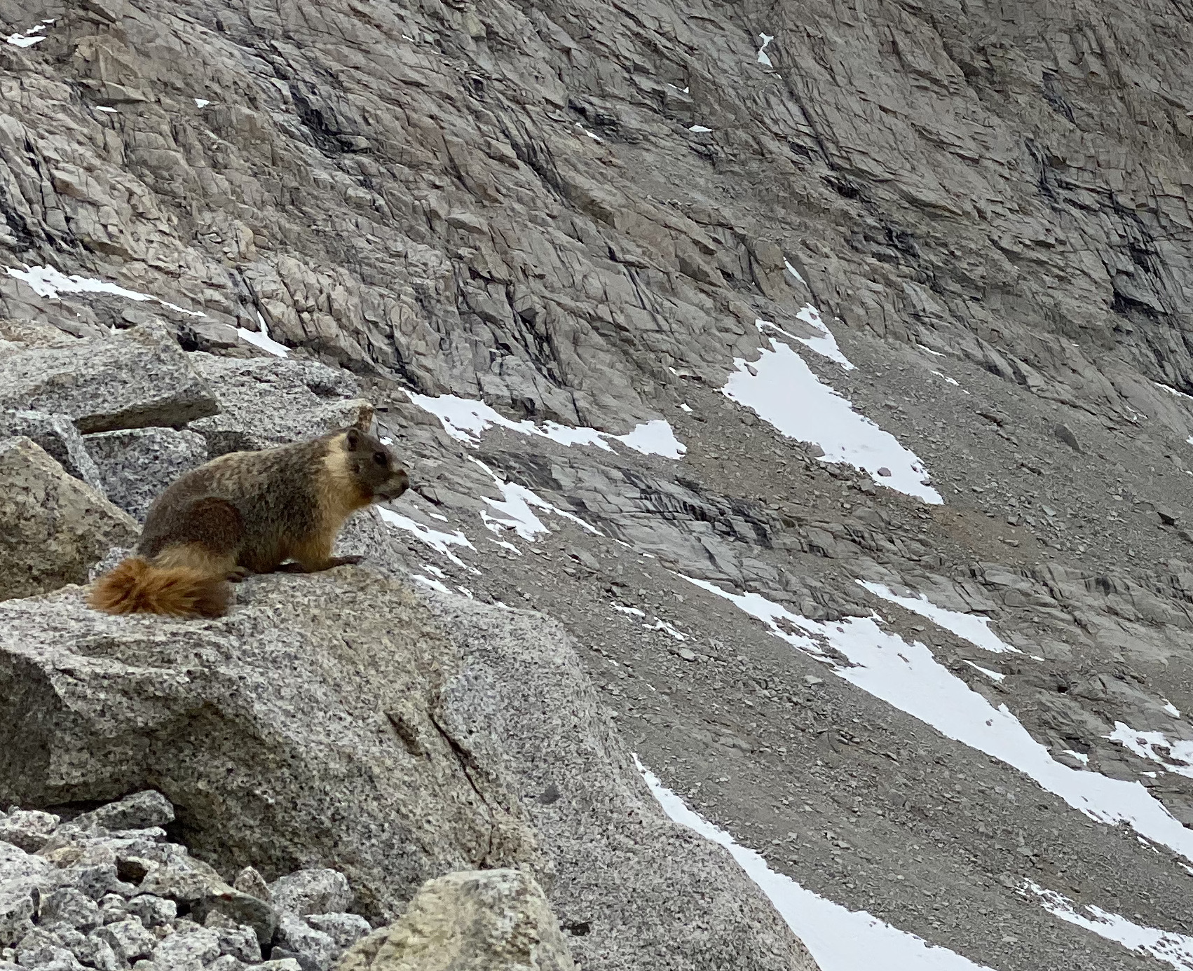
A marmot surveys Forester Pass, Photo Credit: Me

Of course, we encountered many more critters than just birds – from our first day on the trail, we started to see bushy tails hard at work just off or on the trails. They’re probably busy preparing for mating season – marmots are polygynous with the males attracting several females – and so had a lot to get ready. One surprise was the silent treatment we received from these Marmots – on a previous hike late in the season near Washington’s Goat Rocks (1500 miles in Rib’s future), they would stare us down and emit a high pitch bark to warn their burrow-mates.

Pika

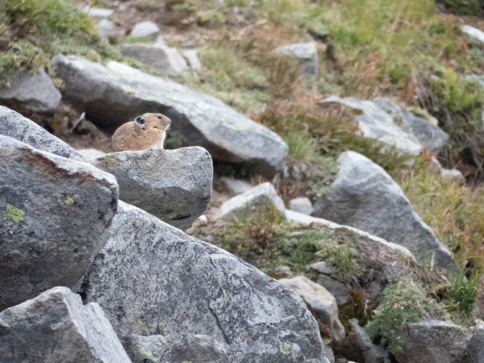
Pika on Mt Rainer, Photo Credit: Me

Speaking of suddenly quiet, we were also surprised by the stony silence we received from Forester Pass’s Pika population. These high-elevation rodents (which we also encountered in the Goat Rocks) are always on the lookout and will squeak to warn the colony when outsiders trespass on the rocky scree where they make their burrows. We only encountered a singular Pika who maybe could tell from our micro-spikes and hurried pace that we wouldn’t be staying long at 13,000 ft as the snow started to fall.

Coyotes

Be cautious of Lake Tahoe's wily coyotes – Toree's Stories | SierraSun.com
Photo Credit: Sierra Sun

Coyotes were with us for almost our whole journey: from the road up to Kennedy Meadows to our first morning on the trail – their omnipresent prints and scat attests that the Sierra are their mountains. I had been feeling left out after both my parents had spotted their own until I finally bumped into one at Guitar Lake on the way down from Mt Whitney. The large coyote ran along the trail, towards but then away from me, pausing when he was far enough along to give me a once-over before a full-body shake. “Eh, not worth it,” it seemed to taunt with that shake before climbing up the valley towards an easier lunch.

The South Sierra is a landscape of contrast – granite peaks tower over some of the driest and lowest parts of North America. That elevation and rain shadow catches moisture as it moves across the continent, cultivating a lush landscape where life – sequoia, juniper, and mountain meadows – can thrive. And it was a great joy to get to hike through it all and take it in.

Categories
Hiking the PCT

The Amazing South Sierra

This is my fifth trip into the Sierra Nevada mountain range. It stretches 400 miles long and about 70 miles wide for a mind-boggling 40M square miles. I got to take the journey through 110 miles of the southern end of this magical place with my son Scott. The scope of this gem is hard to fathom, and the photos shared might blur together. But each and every valley or vista we traveled called for deeper exploration.

One request frequently faced by PCT hikers is for family or friends to join them on a portion of the hike. This often ends badly as the finely tuned bodies and packs required for thru-hiking meet their guests’ not so finely tuned bodies and packs. I had no such concerns about Scott, given his penchant for ultra-marathons and other endurance events. But even he admitted that the 30-year age advantage did not fully account for my 750 miles on the trail. He did, however, make up the difference by the time we reached Mt. Whitney and left me hiking in the dark.

The trip started frantically picking up Scott in Reno, driving six hours to Kennedy Meadows, and sorting gear and food for a week. We got a late start, and neither of us was in very high spirits as the mid-day heat and reality of 110 miles loomed ahead.

Sorting our gear and food for seven days
Leaving Kennedy Meadows with a hot sun and monstrous packs

The first two days were through the transition zone of high desert to alpine abundance. We had to carry water to last a full day, given the infrequent opportunities to fill.

The first day ended at the South Kern River – a morale booster
Our campsite on the second day provided views of what was to come

By day three, we kicked into gear to start climbing from 6K feet into the 10K – 14K feet elevations that would be our new home. The living systems were changing before our eyes.

The Bristlecone Pine forests greeted us at every turn
We camped at an alpine lake at over 11K feet

Days four through six included epic adventures from climbing Mt. Whitney (14.5K ft) before sunrise to hiking through mountain plains that looked like Peru and climbing over Forester Pass (13.2K ft) with a snowstorm closing in. The physicality of the place consumed me – this was tough work. But that faded rapidly as the majesty fueled me. I could spend a week exploring any one of the dozens of mountain basins we saw. This place is a must-see if you lose yourself in wild places.

On top of it all on Mt. Whitney
Looking back at Mt. Whitney, now a tiny bump on the horizon
The mountain plain stretched for miles as we approached Forester Pass
Summiting Forester Pass (13.2K ft) required scrambling over a cornice at the top
We had miles of snow to contend with on the north side of Forester Pass
Our final look back into this fantastic area as we left through Kearsarge Pass

Categories
Hiking the PCT

Good Morning Mt. Whitney

I am sending this post from the highest place in the continental US. My son, Scott, and I started our climb at 2 AM and arrived to watch the sunrise over Death Valley. Scott joined me at Kennedy Meadows, and we have hiked 75 miles and climbed nearly 20K feet. Summiting Whitney was worth every step.

Getting Ready – approaching Mt. Whitney from the east

We hiked into Crabtree Meadows yesterday to prepare for the 7.8 mile, 4K foot climb.

Looking for the trail is a team effort.

We left camp at 2 AM and worked together to find the trail with our headlamps.

Watching the sunrise over Death Valley.
We used sleeping bags to wait for the sun.
At the top of the Continental US.
Exhaling crystals
heart pounds like a pile driver
Mt. Whitney awaits.
                        Ribs