Categories
PCT Preparation

Border to Border – solving the logistic puzzle

Border to border
takes 5.3 million steps
with beginner's mind.

I am watching the cold rain drip off my office window thinking about one year ago – making lists, buying food and gear, all the while wondering what the hell I had got myself into. Even after completing the hike, that is an unanswerable question because everything changes. What I do know is that I prepared as well as I could and then let go of my preconceived notion of what was going to actually happen. I am dedicating this post to all the hikers going through their own preparation while the deeper questions continue to swirl.

I entered my name in the hiker’s journal at the Mexican Border with little idea what was to come.

I have written about my gear and food. This post is about logistics. Self-supported hikers do not have anyone meeting them during the hike. They hitchhike to resupply locations and either pick up boxes mailed to that location or buy food locally. If you are a self-supported thru-hiker, I recommend using this excellent Trail Resupply Guide from Halfway Anywhere. I used the gear reviews posted by Halfway Anywhere extensively in my preparation. His resupply guide paints a clear picture of what self-supported thru-hikers would have done differently. He covers resupply strategy/frequency, mailing boxes versus purchasing food, resupply locations, food selection, and much more. My post focuses on supported hikers and those who support them, but all hikers might find missing pieces to their logistics puzzle.

I was looking way too clean on my first hiking day on March 28 last year from Campo to Lake Marina, 20 miles away. My journey was one of a supported hiker.

I was so fortunate that Pleasure-Way supported me during my 118 hiking days that spanned 151 calendar days. Her support allowed me to adjust as I learned what gear and food I actually needed. Her moral support was even more essential, as was my ability to recover more quickly during my zeros because I didn’t need to hitchhike into town and run errands all day.

I became pretty efficient at the art of resupply, aided by multiple checklists and a stockpile of food and gear. (taken at an RV park in Susanville, CA)

Even though my hiking logistics puzzle was simpler, Pleasure-Way and I had to work on two puzzles simultaneously because the supporting party navigates a complex rural landscape. We both needed to meet at a known place at a specific time. How many of you have had trouble finding your party after getting separated while shopping or at an event. Imagine an event the size of the western US with limited cell service in remote locations and questionable roads. For more information about how to pull all of this off, take a look at my post, Pleasure-Way: an interview with 2021’s best Trail Angel. Constantly adjusting our plan for when and how to meet was more complicated than my resupply puzzle.

Below, I have copied another spreadsheet to aid your planning, Rib’s Border to Border Logistics. This list shows every hiking day and our meeting locations for zeros and resupplies. We became very good at resupply points that did not cost any miles; in fact, they lengthened my days. If I knew I was coming into a resupply, I could push my mileage that day. Nearly half of my 30+ mile days ended in a meet-up with Pleasure-Way. As you use this for your planning, remember that we jumped to northern California twice to avoid snow in the Sierra and meet family members. We were fortunate that we did not have to jump to avoid new fires, but this is now the new reality for many hikers.

As you continue to put your logistics puzzles together, occasionally take a break and walk the hike in your mind’s eye. The beautiful and solitary moments are endless and await your trip of a lifetime. Pleasure-Way and I look forward to seeing you at the Frog Lake trailhead near Mt. Hood on July 22-25.

I was obsessed with the blooming yucca plants from the very first day – some looked like small trees, others like swaying bamboo. Dropping into the high chaparral from rainy Oregon was stunning.
The Mojave desert was dramatic with constant reminders of the fragility of life.
Southern California slowly gave way into the foothills of the Sierra. Darth Vader was with me as I approached Bird Spring Pass.
The southern portion of the Sierra combines desolate mountain basins followed by lush valleys.
Crossing Forester Pass at over 13K feet is always a big day, but even more so with many miles of snow to cross.
If Shangri-La exists, Evolution Valley tops my list of nominees.
The wind was whipping and I wore all my warm clothes climbing Sonora Pass.
I arrived at a much-needed meet-up with Pleasure-Way at the Carter Meadow trailhead in northern California.
The Three Sister’s Wilderness in Oregon offers fast hiking and expansive views.
Staying focused on the trail is all-important on the Knife’s edge in the Goat Rocks Wilderness in Washington.
The Northern Cascades feel like the end of this hike and the start of the amazing Canadian Rockies.
Categories
Hiking the PCT

Leaving Hotel California

"Welcome to the Hotel California
Such a lovely place (Such a lovely place)
Such a lovely face
Plenty of room at the Hotel California
Any time of year (Any time of year)
You can find it here

Last thing I remember, I was
Running for the door
I had to find the passage back
To the place I was before
"Relax, " said the night man,
"We are programmed to receive.
You can check-out any time you like,
But you can never leave!"

<start massive air guitar solo here>
                    Don Henley / Glenn Lewis Frey / Don Felder

The theme song for this blog has been running through my head for 400 miles. I was wondering whether I would ever leave. The California section of the PCT is overwhelming, 1692 miles and a gross elevation gain of 257K feet. And true to the song, the majority of PCT hikers never leave. An estimated 80% of hikers that start the PCT do not finish, and from my observations, most drop out before hitting the Oregon border. It took me 79 hiking days and 22 miles a day to leave. I was struck when standing here that almost two-thirds of the journey is behind me – even more reason to savor every day.

Only the northern terminus milestone on the US/Canadian border is more significant to me than completing California. It felt so good to hike the 20 miles through the Siskiyous and into Ashland through thick forests. I found the passage back to the place I was before.

My blog and photos have been a walking ad for the beauty of California, a great state, to be sure. As I leave, I also have some friendly feedback for the state that considers itself Oregon’s big brother. First, was it really necessary to wind all over the place to see every mountain range? The drive from the Oregon border to Mexico on I-5 is 807 miles. So why did you ask the PCT thru-hikers to hike over twice that many miles? I feel that you are trying a bit too hard to affirm your status. Oregon, home to the humble and efficient beavers, asks hikers to walk 460 miles compared to a 309 mile drive up I-5. We have other incredible sights to share, like the Alvord Desert and the Eagle Cap Wilderness. We could have used a zigzag course and pushed the miles up to a respectable 700 or so. The same is true for Washington. We are missing the Olympic National park, how about a thru-hiker ferry ride?

You get my point; I love you, California, but now I am excited to come home to the forests, bugs, and volcanos. We got this, and you are welcome to visit and leave whenever you want. Here are some funky photos to close this chapter of the journey.

Good intentions aside, this sign on Mt. Laguna from my third day wins the award for least helpful and most discouraging.
The Coulter Pine wins the award for best pine cone. The cones have half-inch knife-like hooks and can weigh up to 11 pounds. No wonder Coulter pines carry the nickname of “widowmakers,” but I believe most life insurance policies exclude this cause of death.
Near Deep Creek Canyon, I kept hearing revving engines. The trail crossed this “road,” which turns out to be a famous off-road challenge course. And people think hiking 12 hours a day is wacko.
The trail passed under I-15, and I just kept walking towards the light. Then I started wondering whether that is what I was supposed to do.
Vasquez Rocks in Agua Dulce brings trail weary PCT hikers through one of Hollywood’s favorite movie sets. Before clicking on this link, test your movie trivia skills and name at least two movies set in this location.
Hiker Town is the “gateway” to the 40-mile trek across the Mojave Desert. The owner gave me a 30′ description of how he bought the land when he learned that then-Governor Schwarzenegger planned to create a subdivision for 100K people in this area. After buying it, he was shocked that homeless people kept stopping by asking for water. It was then he learned about the PCT. The housing development never happened due to a lack of water, so he and his wife created an oasis that is free for the many thru-hikers that pass each year.
We stopped at a remote campground and were invited to join this group of men that had prepared cornish game hens and other goodies for thru-hikes. It turns out that we were being hosted by the current PCTA Board President and other board members.
My son Scott is featured in the best sunset photo, and it also captures how tough it is to choose one’s freeze-dried dinner after a long day. I think biscuits and gravy was the winner.
Scott and I were trying to figure out where Forester Pass was from the top of Mt. Whitney. Good thing there are trails and navigation apps or we would still be wandering around out there.
I loved this DIY Trail Angel stop in the middle of nowhere with all the things a hiker might need and even solar lights for late-night hikers.
Limit Situation Trail Magic was unbelievable. This group of friends set up four days a week to support PCT hikers. The food was amazing; custom-made pizza, homemade burgers, and salads. They even gave us their really cool bandana. If hikers want, you can stay for the evening, and they will cook breakfast. Really good people who feel that spending time in nature is a worthwhile and important experience.
My most dangerous fall came while trying to cross this snowfield before Carson Pass. With the rest of the hikers, I believed the snow was behind us and did not have microspikes. I fell while crossing above the snowfield with exposure to over a hundred-foot steep fall into the rocks. Somehow, I pushed off as I fell and landed on the trail. Every step matters and this one was a massive wake-up call.
The PCT maps missed the fact that we were crossing through the State of Jefferson. Apparently, Seiad Valley was the epicenter to get statehood back in the 1930s, and then WW2 got in the way. The general store has all the State of Jefferson items for sale that you might be looking for. Any aspiring graphic artists might want to help them out with their logo.
Pleasure-Way has been hiking out with me or meeting me at the end of sections. This picture is heading north out of Sonora pass.

Categories
Hiking the PCT

Northern Sierra Melting Pot

PCT hikers generally assume that the Sierra Nevada section ends at Sonora Pass, where they are relieved to stop carrying their food in a bear canister. Geologists know the Sierra continues another 270 miles to the North Fork of the Feather River, where I ended hiking today. The name “melting pot” came to me early as I saw the ever-changing combinations of high desert, deep forests, polished granite, basalt columns, and volcanic cones. The name made even more sense as I started to adjust to the heatwave that swept across the west.

I have now closed the gap between California’s southern sections with the start of the Cascades. I am excited to be at mile 1501 and ready for my trek northward from Castle Crags. Heat is my new reality, and once again, I need to re-think my gear and approach. I hiked three days with temperatures bordering on 100 degrees, and I immediately noticed the added energy required to cool my body when I am already operating in a caloric deficit. My plan is to lighten my gear and carry more food, but one thing I can count on is continuously making adjustments.

The Desolation Wilderness is a small but spectacular section near South Lake Tahoe starting with Aloha Lake.
Climbing up Dick’s pass provides a great view of Suzie Lake in the foreground and Aloha Lake in the distance. The polished granite reminded me of Yosemite, but the volcanic peaks look much more like the Cascades.
I like to start hiking around 6 AM and then enjoy a proper second-breakfast of gourmet oatmeal and coffee. This friendly face watched me as I sat above Lake Tahoe.
I stopped dead in my tracks when I spotted this “Tahoe Bouquet.” It was as if someone had arranged the Mules Ears (yellow), Indian Paintbrush (red), and Nuttall’s Larkspur (purple).
After leaving Donner Pass, I had my first sustained thunderstorm. Sierra Buttes flashed ominously in the distance.
Hiking Sierra Buttes was a 3500-foot climb from Sierra City, featured in Cheryl Strayed’s book and movie. I got started at 6 AM, and the views looked more like Oregon and Washington.
The hottest and most difficult section covered over 20 miles of hiking through the North Complex fires of 2020. The 100-degree heat radiated back from the barren landscape. This was my most challenging day yet on the trail.
One hiker described the Canyon Valley Spring as the “cold nectar of the gods.” These springs tap into artesian sources where hikers can reach the water before it disappears into the dry ground.
100 Degree Hiking
    Heat comes in waves
    Straining my body's cooling
    Each breeze is pure joy
         Ribs
Categories
Hiking the PCT

1325 Father’s Day Gifts

It is hard to believe that I have now hiked past the PCT halfway point of 1325 miles. I do not think it was a coincidence it happened on Father’s Day. I spent my day trying to remember as many family hiking trips as possible. We had trouble keeping track, so we made a list that now tops 50 hikes. As my thoughts bounced between memories, I realized that I had missed the essential point. Our enjoyment of the outdoors was only made possible because of how genuinely gung-ho everyone was and still is to take these adventures. The family must embrace family vacations, and I had never appreciated how much it shaped the journey I am now on.

The majority of our trips were base camping, where you backpack into a scenic location and hang out together. Let’s be honest; these are a pain to plan and pull off. You’ve got to organize everything, including what food kids will eat, cram everyone and the gear into a car for a long drive. The packs are notoriously heavy, start times often in the heat of the day. The mosquitoes show up just as the energy dims. Finally, life on the trail is not exactly comfortable – sleeping on the ground and the lack of bathrooms is a whole other chapter. There is a lot to douse one’s enthusiasm. And yet, since 1997, we have been out there again and again. So, I dedicate the first half of my hike to those who jumped in with both feet every time.

Glissade training on Mt. Rainier in 1996
Our first family backpacking trip into Green Lakes in 1997 (I was 6’2″ before putting on this 70 lb pack)
Snow in the Wallowas in 1999 (why are these people smiling?)

As a recap, I have covered 1366 miles in 63 hiking days for about 21.5 miles per day. Numbers don’t tell the story because every day, mile, and bend in the trail unfolds independently. Poet David Whyte wrote the poem Start Close In, which is the perfect prompt for a long and uncertain journey. The opening stanza comes to mind when I look back at the first mile marker on the PCT.

Start Close In (First Stanza)
     Start close in,
     don’t take the second step
     or the third,
     start with the first thing
     close in,
     the step
     you don’t want to take
             David Whyte
Fortunately, these were not posted every mile.
I had to work through many issues to reach 100 miles
The 1000 mile mark was towards the end of the Sierra
The midpoint marker is fitting, an unremarkable post in a densely forested section of Mt. Lassen National Park
Categories
Hiking the PCT

Juneuary in Yosemite

Freezing wind and hail
will surely tear me apart.
Dawn comes, I'm still here.
          Rib's tent

Several days into my six-day, 117-mile hike from Mammoth Lakes to Sonora Pass, a day hiker gave me the title for this post. As I shared my misadventure, he said, “Oh, I guess you haven’t heard about Juneuary in Yosemite.” My blank face was a sufficient answer. By the way, Urban Dictionary defines Juneuary as a Washington thing.

Storm clouds hung over Ansel Adams Wilderness all afternoon before the storm broke loose.

During my first day after leaving Mammoth Lakes, I was hit by an unexpected storm that dropped the overnight temperatures into the teens with wind gusts to 40 mph and snow. It was the coldest night of the entire PCT. Fortunately, my tent held up and I stayed warm in my sleeping bag; it is the best.

Everything was frozen in the morning, including small streams.

I decided to get moving early to warm up – I had two passes to climb before getting to Tuolumne Meadows. The temperature was still below freezing but it had warmed by the time I summited Donohue Pass, the last pass over 11K feet. A ranger reminded me that I had entered Yosemite and, honestly, I thought it an odd comment. We have crossed through dozens of national forests, parks, and wilderness areas by this time. Looking back, he was also giving me a heads up that Yosemite is different.

I reached Thousand Island Lake before starting my first pass
Snow on the mountains surrounding Donohue Pass

Tuolumne Meadows is the gateway to Yosemite missed by 99% of park visitors. It starts with a series of beautiful meadows and the Lyell Fork of the Tuolumne River as it meanders through the smoothly polished granite peaks. From there, I descended into thick forests and met my new nemesis, the mosquito. The snowpack was deeper in Yosemite than the southern Sierra and had just melted. The one thing every backpacker knows is that you stay home in June when the masses rise from the still water looking for blood. Now I know that thru-hiker DNA dominates the mosquito gene pool. Those tiny beings can drive all of us sophisticated humans insane.

Your purpose is clear
to sip one drop of my blood
anger is no match
          Ribs (trying to chill out)
Hiking by the Lyell Fork of the Tuolumne River
The deep forests of Yosemite were such a contrast to previous barren landscapes.
Dorothy Lake provided a breeze to keep the bugs at bay during an extended lunch stop.

The third challenge in Yosemite started on day 3, the quantity and pitch of the climbs. The peaceful meadows turned into repeated 1000 foot climbs and descents over “trails” that looked more like scenes from Mordor.

Days three through five included an unrelating series of named and unnamed passes over this rugged terrain.
This is one of the more organized trail sections with others looking like stream beds. About 20% of the hikers I talked with developed ankle or knee issues from the constant pounding.

The final day was amazing as I climbed out of Yosemite into the Edison and Emigrant Wilderness areas. The landscape completely changed to wide open climbs and vistas stradling Mt. Leavitt. I was ecstatic to meet Pleasure-Way for a much-needed zero, and we were lucky to give Magic Marker and Steps a lift into town.

The climb was gradual switchbacks but had five different summits to view every side of this new landscape.
The wind provided a constant light show reflected from the lake
Magic Marker and Steps getting recharged on the way into town
Categories
Hiking the PCT

Big Week

Thru-hiking like life
brings toil and uncertainty
to ask who am I?
Ribs

I am writing from the comfort of a motel in Mammoth Lakes. I came off the trail today after the most physically challenging week so far with a profound appreciation of the scenic beauty and the responsibility we assume when thru-hiking. In seven days I covered 123 miles with 32K elevation gain from eight passes averaging over 11K feet.

I was joined by my nephew, Peter, an experienced Sierra climber and back country skier. His presence boosted my confidence to navigate the three highest passes with snow.

Kearsarge Pass, at nearly 12K feet, is required just to get back to the PCT
Glen Pass, our second 12K pass of the first day, required several steep snow field traverses – not a big deal for Peter but I fell several times
Looking back at Glen Pass from the Rae Lakes

I could have written a nice post titled “Big Day – The Sequel” after two major climbs on the first day. But we were just getting started. Every day we climbed as quickly as possible to summit the next pass before the snow got too soft or possible afternoon thunderstorms materialized. We then dropped 3K feet to the valley floor to camp before starting the sequence again. It makes me tired just listing our Big Week itinerary.

  • Day 1: Kearsarge 12K and Glen 12K
  • Day 2: Pinchot 12K
  • Day 3: Mather 12K
  • Day 4: Muir 12K
  • Day 5: Selden 11K
  • Day 6: Silver 11K
  • Day 7: Mammoth 10K
We met him at first light of day 2 sharing the river valley, the first of many deer over the week
Pinchot Pass featured the barren moonscape of the southern Sierra
Looking back from Mather to Pinchot Pass showed our day 3 work

Peter and I were most concerned about Muir Pass because of the snow depth. It was the most scenic section of the PCT so far. The intense azure blue of the lakes and sky radiated off the snow and ice.

Peter leads the way up Muir Pass
The John Muir shelter, built in 1930, saves lives when storms close in on this highly exposed landscape
Wanda Lake, north of Muir Pass, defines radiance
The ice flow moved with the wind, I had to peel my eyes away lest I would still be sitting there

The descent from Muir took us into the magical Evolution Valley. I have tried to hike this section for years but permits and fires have intervened. It is the transition from the barren Sierra peaks to the lush forests that stretch from valley floor to alpine lakes.

We shared our campsite view with the residents of Evolution Valley

The constant pounding of the descents took a toll on Peter. He dealt with a daily barrage of blisters but then he re-activated knee issues that quickly escalated. He decided to hike 16 miles out rather than continue 45 more miles and risk an evacuation. It was a hard decision but demonstrated the most important responsibility we have in remote wilderness situations – know your limits at every moment. Later we concluded the issue was likely using climbing approach shoes. Every thru-hiker tweaks their gear, food, and body care over weeks and months – Peter had five days.

Foot care at its best

I continued north to finish the last three passes and 45 miles. I had hiked this section with Jenessa in 2017 so it was fun to experience the trail again and remember the trip that inspired me to hike the PCT.

Silver Pass was number seven and a crazy day of climbing
After a full meal, I decided to take on a mammoth mud pie. You’re damn right I finished it with an audience at the next table.
Categories
Hiking the PCT

Scott: Wildlife in the South Sierra

A few weeks ago, I was lucky enough to get on the trail with Ribs for a beautiful stretch of California. Starting at Kennedy Meadows and finishing up at Kearsarge Pass (read all about it if you missed it). The trip was a great endnote for my year-plus of COVID-19: It kicked off with a final vaccine dose, my first air travel in over a year, and hugs from family members. But it also was an opportunity to put to use while backpacking a past-time I picked up during lockdown: Bird Watching.

Bird Watching and thru-hiking seem like an uneasy pair; often, you get the best results birding by standing still and walking very, very slowly, anathema to a thru-hiker who’d rather be on their feet or sleeping. However, just by being up for almost the whole day – you’re given an opportunity to observe birds and critters as they go about their days and see how their rhythms match or miss that of a hiker.

Along our 110 mile hike, we spotted several birds (and other critters) that I often see around Portland – Juncos, Chickadees, Crows, Chipmunks – but I wanted to share a few of my favorites that I notice along the trail:

Cliff Swallow

Cliff Swallow | Audubon Field Guide
Photo Credit: Audubon Society

Even before we hit the trail, we were bumping into Cliff Swallows as we boondocked at Kennedy Meadows, and they also greeted us at our first camping site along the S Fork of the Kern River. These little birds will make nests alongside the edge of cliffs (or bridges in these cases) made of mud and swarm into huge flocks to catch bugs. As the sunset on the first night, Ribs and I watched them fill up the sky. These little guys tended to come out when we were making or breaking camp.

Clark’s Nutcracker

Clark's Nutcracker Identification, All About Birds, Cornell Lab of  Ornithology
Photo Credit: All About Birds

After we’d hit the trail and got moving through a sparse forest of ancient and sometimes fire-scarred sequoias – we’d often spot these flitting in between the trees, usually at the edge of our vision. They didn’t tend to call out, but you’d see them watching us along the trail. A relative of crows and jays – they tended to be a bit shy – staying active throughout the day on our hike, only disappearing around late afternoon.

Townsend’s Solitaire

Townsend's Solitaire Adult
Photo Credit: All About Birds

As we ascended higher into the Sierra – camping at 7000 ft, then 9000, then never coming below 10,000 – I noticed a very complex bird call that would start in the mid-morning and then reemerge in the later evening. It took me a few days to finally spot the culprit – this small gray bird that would hang out on shrubs. It’s apparently a huge fan of juniper and likes to hang out in the higher elevations during the breeding months.

Gray-crowned Rosy Finch

Gray-crowned Rosy-Finch Identification, All About Birds, Cornell Lab of  Ornithology
Photo Credit: All About Birds

We climbed Mt Whitney at sunrise on the fifth day and hunkered down to eat our breakfast from the wind. One of these little fellas took our presence as an open invitation to crash our party – coming very close to our sleeping bags and oatmeal. Despite our protestations – it persisted by dodging and weaving around us to gain access to our treats. Another high-altitude forager, these birds can often be found on snowfields foraging for seeds. Stealing food from altitude-addled climbers does seem much easier by comparison.

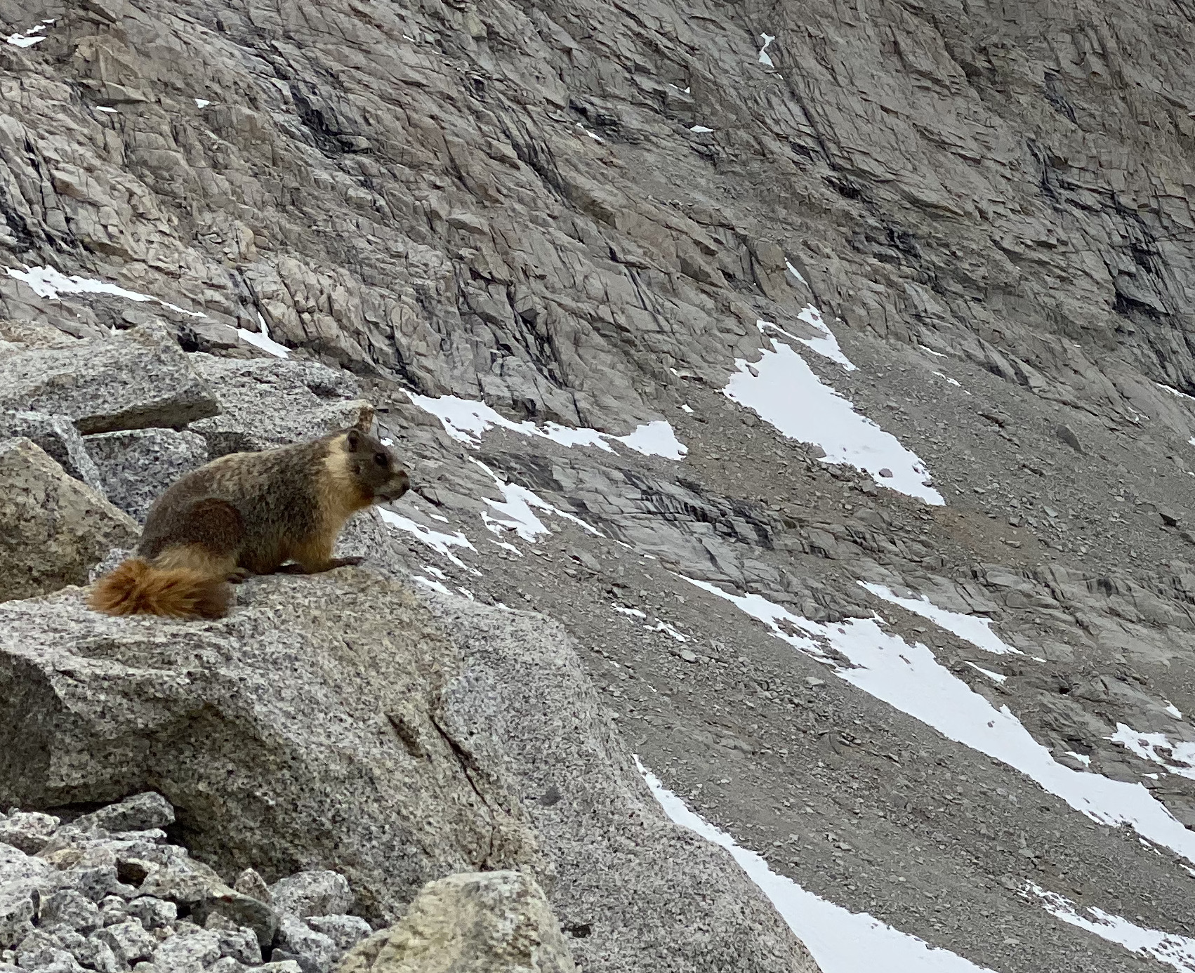
Yellow-bellied Marmot

A marmot surveys Forester Pass, Photo Credit: Me

Of course, we encountered many more critters than just birds – from our first day on the trail, we started to see bushy tails hard at work just off or on the trails. They’re probably busy preparing for mating season – marmots are polygynous with the males attracting several females – and so had a lot to get ready. One surprise was the silent treatment we received from these Marmots – on a previous hike late in the season near Washington’s Goat Rocks (1500 miles in Rib’s future), they would stare us down and emit a high pitch bark to warn their burrow-mates.

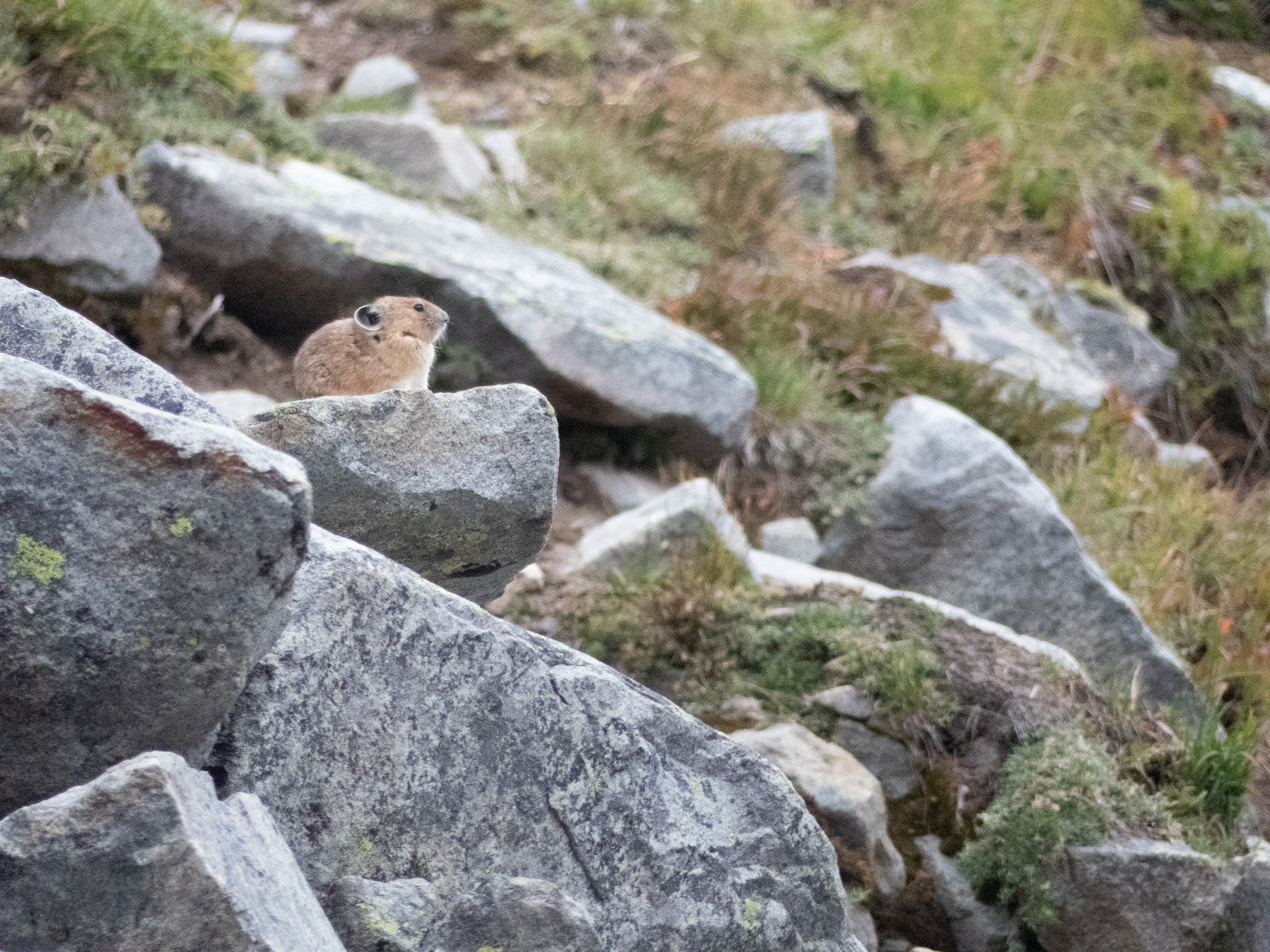
Pika

Pika on Mt Rainer, Photo Credit: Me

Speaking of suddenly quiet, we were also surprised by the stony silence we received from Forester Pass’s Pika population. These high-elevation rodents (which we also encountered in the Goat Rocks) are always on the lookout and will squeak to warn the colony when outsiders trespass on the rocky scree where they make their burrows. We only encountered a singular Pika who maybe could tell from our micro-spikes and hurried pace that we wouldn’t be staying long at 13,000 ft as the snow started to fall.

Coyotes

Be cautious of Lake Tahoe's wily coyotes – Toree's Stories | SierraSun.com
Photo Credit: Sierra Sun

Coyotes were with us for almost our whole journey: from the road up to Kennedy Meadows to our first morning on the trail – their omnipresent prints and scat attests that the Sierra are their mountains. I had been feeling left out after both my parents had spotted their own until I finally bumped into one at Guitar Lake on the way down from Mt Whitney. The large coyote ran along the trail, towards but then away from me, pausing when he was far enough along to give me a once-over before a full-body shake. “Eh, not worth it,” it seemed to taunt with that shake before climbing up the valley towards an easier lunch.

The South Sierra is a landscape of contrast – granite peaks tower over some of the driest and lowest parts of North America. That elevation and rain shadow catches moisture as it moves across the continent, cultivating a lush landscape where life – sequoia, juniper, and mountain meadows – can thrive. And it was a great joy to get to hike through it all and take it in.

Categories
Hiking the PCT

Cascading

In our attempt to hike the entire PCT this summer, we have been jumping north to hike short sections of the trail while waiting for the snow to melt in the Sierra. These disjointed sections were, in fact, a wonderful introduction to the Cascade Mountains. I hiked 214 miles from Belden to Castle Crags State Park on I-5 in four hikes over nine days through the Mt. Lassen and Mt. Shasta National Forests.

This sign announcing entry into the Cascades Range is 400 PCT miles from the Oregon border.

In my initial attempt to hike up north three weeks ago, Home Alone, I didn’t see many people but did find signs of bears and plenty of snow. These themes continued as I encountered only five parties backpacking over the entire distance. It was unnerving at first, but I came to appreciate the solitude. Signs of bears continued, and I spent time trying to understand their activities – I never saw one, which is always the goal. And, yes, the snow found new ways to tease and torment, reminding me that I am simply a visitor in nature’s house.

Looking 30 miles south at Mt. Lassen from Hat Creek Rim
Looking 100 miles north at Mt. Shasta from Hat Creek Rim
A recent bear print near Mt. Lassen
Bear scat full of Juniper berries inspired me to alert them near Juniper groves.

The next time we jumped north to avoid a snowstorm in the Sierra came after The Amazing South Sierra. I began by hiking a 46-mile section near Mt. Lassen, thinking that the worst of the snow would hit in the Sierra. I stayed with Pleasure-Way after completing that section and was surprised to find four inches of snow at our campsite the next day and likely six to eight inches covering my planned route. We decided to make a quick dash home and found that the snow stretched far north into Oregon at PCT trail elevations.

Fresh snow on May 20 at Old Station near Mt. Lassen 2,500 feet below where I was hiking the day before
The snow highlighted the magnificent trees in the Mt. Lassen National Park

We returned after a few days to complete the section. I will leave you with some visual and poetic images of the southern Cascade Mountains. I look forward to hiking the remaining 1,150 miles of the Cascades after I complete the Sierra.

The Sugar Pine trees were the winner in the pine cone category, with a close second going to the Gray Pines.
My campsite at sunrise looking down on Lake Almanor
Snow plants signal the start of spring, bursting forth from snowbanks
Emerging from snow
everything given freely
sweet nectar of life.
              Ribs

Categories
PCT Reflections

What’s in a (trail) Name?

I dreaded the thru-hiking tradition of receiving a trail name. I made snarky comments to others like, “what is this, summer camp, come on.” Most people would shrug at my lack of creativity, but a Norwegian hiker vociferously countered my disdain. He said, “you see, the trail name is important, and it must be given to you by another hiker because something funny happened. When you meet people, you tell them your trail name and then your story – and they laugh and remember you.”

Ribs, Twister, Pilot, Pack Mule, and Rabbit

Upon some reflection, my reaction was masking some deeper insecurities. The idea of being given a trail name conjures unpleasant and downright mean nicknames. Since I am hiking solo and am coming off the trail to stay with my trail angel, I am not hanging out in the hiker hostels where the funny business truly happens. Who will know me or even care about the sexagenarian that hikes at a steady pace 12 hours a day – nothing funny or exciting about that. Even in high school, Shakespeare’s Juliet taught me the significance of our names when she asked, “What’s in a name?” But all that changed with my trail family.

I met Twister many miles ago and did him a favor by giving him a ride. When hiking together, we ran into the rest of the crew, drinking at high noon in Agua Dulce. By chance, I camped with them after crossing the Mojave – and a family with no name was formed. Our family was diverse in years, with 30, 40, 50, and 60-year-olds. We hiked hard for eight days together, covering almost 25 miles a day.

As always, the daily conversation centered on water, how much we needed to carry, and whether there was a reliable source at day’s end. I realized that my trail angel could meet us with the van to provide water. But instead of just water, she brought ribs, beer, fruit, and more. Rabbit gave me the name Ribs and my motto – the trail provides. My name encourages me to pack more food, lest my ribs become a dominant torso feature. Beyond that, my name reminds me of my impermanence and calls me to be present for each and every step

My trail angel’s trail magic prowess grew. She has met and supported over fifty hikers with food and drink that make all the difference. Twister offered her a trail name, Pleasure-Way, to honor the van that she drives, becoming a beacon for those who need an extra boost to keep moving.

Hikers gathering for trail magic at an obscure road crossing
Twister, in red, offered the name Pleasure Way, after feasting on chicken beer, fruit, and Pop Tarts
Miyagi, Twister, and Pack Mule making quick work of carbo-loading for the upcoming 2K foot climb

Categories
Hiking the PCT

The Amazing South Sierra

This is my fifth trip into the Sierra Nevada mountain range. It stretches 400 miles long and about 70 miles wide for a mind-boggling 40M square miles. I got to take the journey through 110 miles of the southern end of this magical place with my son Scott. The scope of this gem is hard to fathom, and the photos shared might blur together. But each and every valley or vista we traveled called for deeper exploration.

One request frequently faced by PCT hikers is for family or friends to join them on a portion of the hike. This often ends badly as the finely tuned bodies and packs required for thru-hiking meet their guests’ not so finely tuned bodies and packs. I had no such concerns about Scott, given his penchant for ultra-marathons and other endurance events. But even he admitted that the 30-year age advantage did not fully account for my 750 miles on the trail. He did, however, make up the difference by the time we reached Mt. Whitney and left me hiking in the dark.

The trip started frantically picking up Scott in Reno, driving six hours to Kennedy Meadows, and sorting gear and food for a week. We got a late start, and neither of us was in very high spirits as the mid-day heat and reality of 110 miles loomed ahead.

Sorting our gear and food for seven days
Leaving Kennedy Meadows with a hot sun and monstrous packs

The first two days were through the transition zone of high desert to alpine abundance. We had to carry water to last a full day, given the infrequent opportunities to fill.

The first day ended at the South Kern River – a morale booster
Our campsite on the second day provided views of what was to come

By day three, we kicked into gear to start climbing from 6K feet into the 10K – 14K feet elevations that would be our new home. The living systems were changing before our eyes.

The Bristlecone Pine forests greeted us at every turn
We camped at an alpine lake at over 11K feet

Days four through six included epic adventures from climbing Mt. Whitney (14.5K ft) before sunrise to hiking through mountain plains that looked like Peru and climbing over Forester Pass (13.2K ft) with a snowstorm closing in. The physicality of the place consumed me – this was tough work. But that faded rapidly as the majesty fueled me. I could spend a week exploring any one of the dozens of mountain basins we saw. This place is a must-see if you lose yourself in wild places.

On top of it all on Mt. Whitney
Looking back at Mt. Whitney, now a tiny bump on the horizon
The mountain plain stretched for miles as we approached Forester Pass
Summiting Forester Pass (13.2K ft) required scrambling over a cornice at the top
We had miles of snow to contend with on the north side of Forester Pass
Our final look back into this fantastic area as we left through Kearsarge Pass